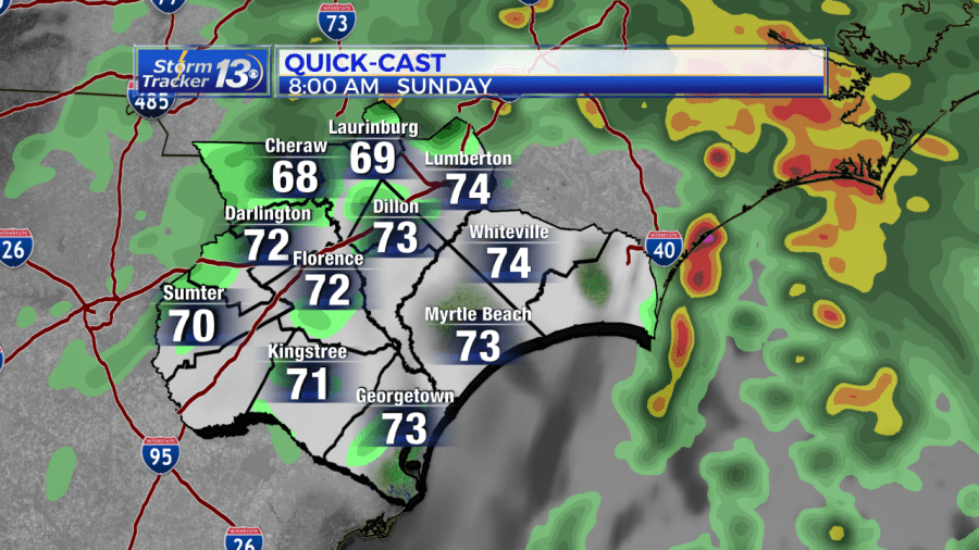
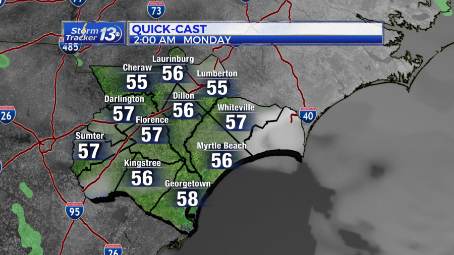
8 AM UPDATE: The low pressure that once was Nestor is moving into North Carolina and we’ll see improving conditions through the day. It’ll remain mostly cloudy and breezy through morning. winds 10-20mph. An isolated shower is possible through morning, but not expecting any heavy rain In fact we’ll see some sunshine this afternoon. Winds will die down overnight and we’ll see mostly clear skies and cool conditions to start your Monday.
7AM WEATHER UPDATE: The storm system that was formerly Tropical Storm Nestor is moving through North Carolina and is expected to move offshore late this evening.
A few showers will linger this morning, then it will clear as the storm moves away. Today we’ll start off very warm and muggy and a slight drop in temperatures through the afternoon.
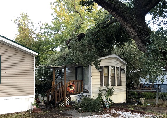
A tornado warning was issued for parts of Horry County from about 1:45 a.m. until 2:15 a.m. on Sunday. Some damage has been reported in the Shady Grove mobile home park in Myrtle Beach where a tree fell on a home. Cont on News13 as we work to gather more information.

11 PM UPDATE: Severe thunderstorms have not yet materialized. The only severe weather this evening has been in central Georgia, and that thunderstorm will stay south of Savannah. Expect periods of rain, heavy at times with the chance for a thunderstorm. There will still be a risk for severe storms, but they should not be widespread.
8:30 PM UPDATE: Periods of rain continues across our part of the Carolinas. The area of low pressure that was Tropical Storm Nestor is located in central Georgia with a warm front extending to just south of Charleston. It is along and south of this warm front where we can expect a chance for severe thunderstorms, including isolated tornadoes. This front may push into Georgetown County after 10pm, then through the rest of our area, east of I-95, through the rest of the overnight. The main threat overnight will be for these severe thunderstorms containing damaging wind gusts or isolated tornadoes.
5 PM UPDATE: Nestor is no longer a tropical system, and the National Hurricane Center has issued its final advisory on the storm at 5 p.m.
Periods of rain will continue through tonight with 1-3 inch storm totals expected. It will be windy tonight with winds at 15-25 mph.
There is also a slight risk for severe thunderstorms from 10 p.m. until 6 a.m. If these storms develop, there will be a chance for damaging wind gusts and isolated tornadoes.
2 PM UPDATE: Nestor has made landfall on St. Vincent Island, FL.
The post-tropical storm is bringing with it 45 mph winds.
It’s heading north-northeast at around 23 mph.
Nestor is no longer a tropical system, and will continue to weaken as the center of the storm moves over land. Periods of rain will continue through the afternoon hours. 1-3 inches of rain is expected in our part of the Carolinas. This will be good news and drought relief, and no flooding problems are expected. Winds will increase this afternoon to 15-25 mph with gusts as high as 40 mph along the coast. Outside of any thunderstorms, wind damage is not expected. There is a slight risk for severe thunderstorms this evening and overnight, including a chance for an isolated, weak tornado. This tornado threat will be between 6pm and 2am, and will occur if warm, humid air can make it as far north as the Carolinas. The best chance for a tornado will be close to the coast.
11 AM TROPICAL UPDATE: Nestor is no longer a tropical system, and will continue to weaken as the center of the storm moves over land. At 11am, the center of the storm was still over the Gulf of Mexico, just off the Florida Panhandle coast, but all heavy rain and thunderstorm activity is displaced far to the east of the center of the storm.
Periods of rain will continue through the afternoon hours. 1-3 inches of rain is expected in our part of the Carolinas. This will be good news and drought relief, and no flooding problems are expected. Winds will increase this afternoon to 15-25 mph with gusts as high as 40 mph along the coast. Outside of any thunderstorms, wind damage is not expected.
There is a slight risk for severe thunderstorms this evening and overnight, including a chance for an isolated, weak tornado. This tornado threat will be between 6pm and 2am, and will occur if warm, humid air can make it as far north as the Carolinas. The best chance for a tornado will be close to the coast.
8 AM TROPICAL UPDATE: Tropical Storm Nestor will make landfall along on the Florida Panhandle this morning, and will quickly weaken and transition to a non-tropical storm system. The former tropical system will move across the Carolinas tonight, bringing rain, wind and the threat for tornadoes along the coast.
The rain and wind will increase this afternoon and continue overnight. Rain amount will average between 1-3 inches. No flooding is expected. Winds will average 15-25 mph with gusts to 40mph possible along the coast. Damaging winds outside of thunderstorms are not expected.
If this storm can bring warm and humid air into the Carolinas, there will be a threat for isolated tornaodes. This threat is between 6pm and 2am, and mainly right along the coast.
The remains of Tropical Storm Nestor will move away from our part of the Carolinas first thing Sunday morning. A shower or two is possible early, but skies should clear with sunshine returning.
11 PM TROPICAL UPDATE: Tropical Storm Nestor still moving at north east now at 23mph. Not much has changed with the previous forecast
5 PM TROPICAL UPDATE: As of 5 p.m. Friday, Tropical Storm Nestor has winds of 60mph and is moving northeast at 22mph.

Tropical Storm Nestor in the Gulf of Mexico will bring rain for the weekend. This system will be weakening as it moves over the Southeast, so the main impact will be heavy rain for the Carolinas.
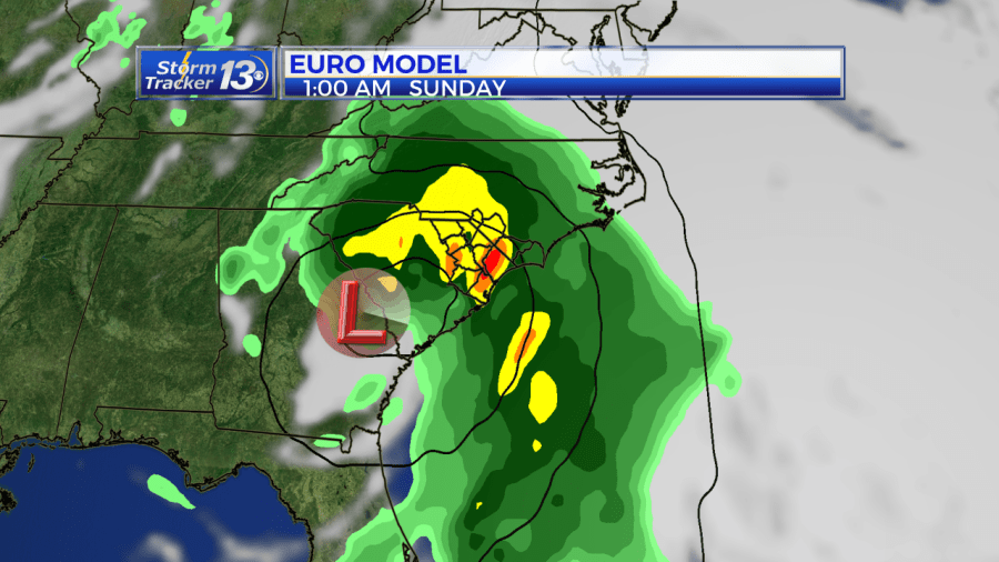
We will see periods of rain on Saturday afternoon with heavy rain possible late Saturday and Saturday night. Two to four inches of rain is possible. Sustained winds expected 25-35mph, however winds could gust 30-40 with an isolated 50mph gust at the coast.

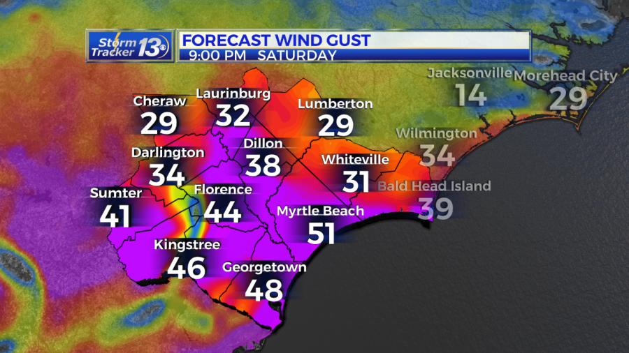
Conditions will start to go downhill after 5pm. There is a small chance for severe thunderstorms, including tornadoes along the coast if this storm system draws enough warm air into the Carolinas. A few showers may linger into Sunday morning, but it will clear on Sunday.
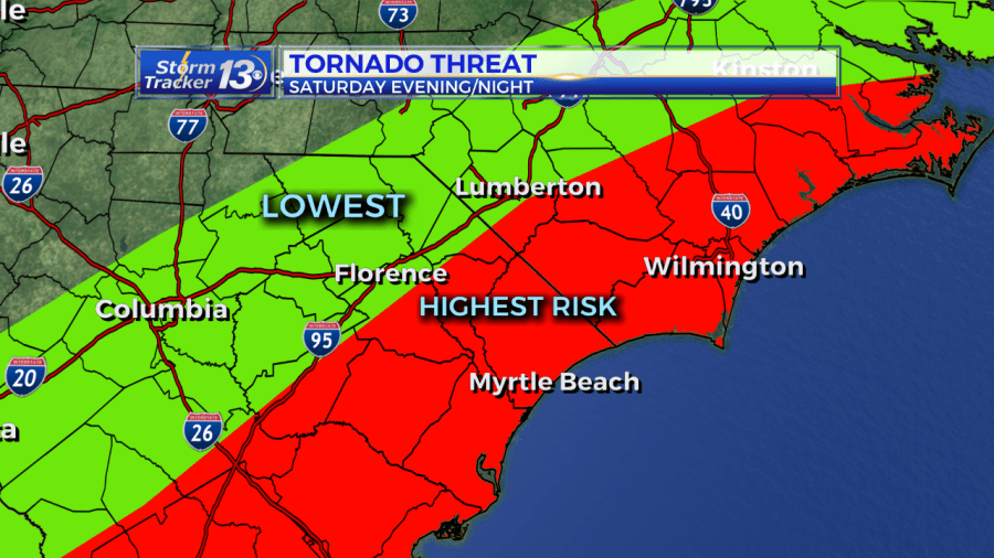
2 p.m. Friday update: Tropical Storm Nestor formed in the Gulf of Mexico on Friday.
The National Hurricane Center had been closely tracking the disturbance in the gulf all week. That disturbance strengthened to become Nestor around 1:30 p.m. ET on Friday.
The system is moving to the northeast at 22 mph and is expected to make landfall early Saturday morning.
For the News13 viewing area, this means rain chances increasing early Saturday. Most of the area will see wind gusts and rain Saturday evening, with anywhere from 2 to 4 inches of rain expected.
The storm is packing maximum sustained winds of 60 miles per hour as of Friday afternoon.
The NHC says there is a danger of life-threatening storm surge inundation up to 5 feet along the Florida Gulf Coast from Indian Pass to Clearwater Beach. Portions of the central and eastern Gulf Coast may experience tropical-storm-force winds.
Isolated flash flooding is also possible along the central and eastern Gulf Coast and the southeastern United States through Saturday night.


