7AM FLORENCE UPDATE:
Tropical Storm Florence continues to sit over the Grand Strand, Pee Dee, and North Carolina. The heaviest rain Saturday morning is expected just north of Myrtle Beach, in Little River and through the Border Belt. As of 7 a.m., heavy rain is pounding North Carolina and moving its way into Lumberton. Florence will continue to make a southwesterly turn into Saturday morning before jumping on a westerly track and settling in for the day – continuing to dump rain on the area.
Flooding is the major concern with significant amounts of rain. Much of North and South Carolina is in a Flash Flood Warning. As we go throughout Sunday afternoon, the storm with begin its move to the north. We’ll continue to see rain throughout Sunday, but not as widespread as we’ve seen over the past three days. On-and-off rain will continue through Monday, with Tuesday bringing drier weather for the Grand Strand and Pee Dee.
3AM FLORENCE UPDATE:
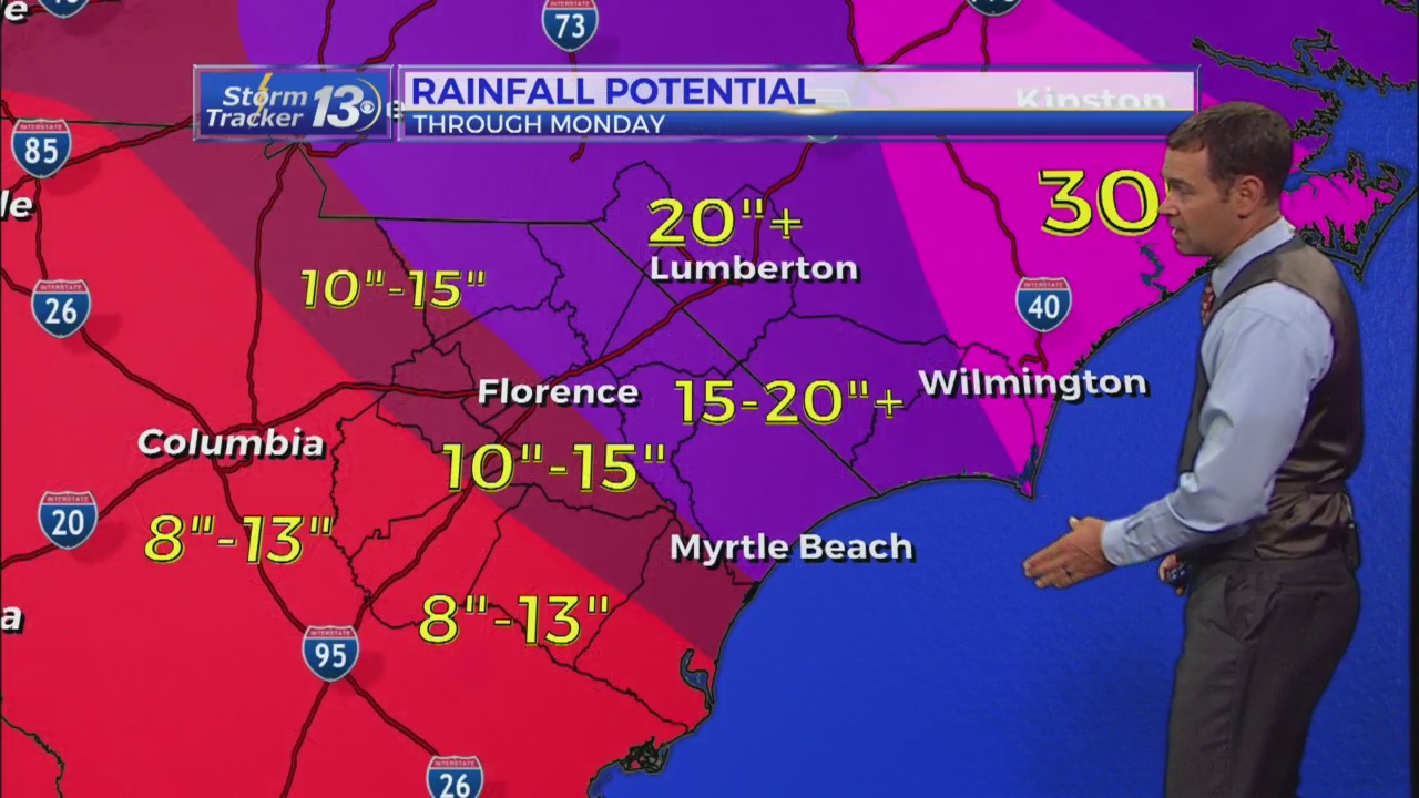
Florence remains a strong tropical storm with winds at 60 mph and possibly even higher gusts. Reports are coming in from Marion and Florence co of gusts near 60 mph in some of the stronger bands of rain moving through. The center of of the storm has moved across Horry Co and is moving WSW at 5mph. The storm is still moving extraordinarily slow. Florence will continue this slow forward motion throughout the day on Saturday while the storm gradually weakens.
Flooding is becoming the largest threat as the storm gradually weakens. River Flood Warnings are in effect for all area rivers for potentially record crests through midweek. Accumulations of up to 20″ or more are possible in counties along the NC/SC border through Sunday. Winds will lighten up by then, although it will still be breezy. A good chance for rain will continue through Tuesday before we start to dry out. We will watch for the possibility for an isolated tornado or two across the parts of Horry coutny and the Border Belt this afternoon and evening.
10 pm update:
Florence remains a strong tropical storm with winds at 70 mph and possibly even higher gusts. Reports are coming in from Marion and Florence co of gusts near 60 mph in some of the stronger bands of rain moving through. The center of of the storm has moved across the border into extreme eastern Horry Co near Little River and the Loris area. The storm is still moving extrodinarily slow, a whopping 3 mph. Florence will continue this slow forward motion throughout the day on Saturday while the storm gradually weakens.
Flooding is becoming the largest threat as the storm gradually weakens. River Flood Warnings are in effect for all area rivers for potentially record crests through midweek. Accumulations of up to 20″ or more are possible in counties along the NC/SC border through Sunday. Winds will lighten up by then, although it will still be breezy. A good chance for rain will continue through Tuesday before we start to dry out.
4:45PM UPDATE:
Florence weakened to a Tropical Storm around 4:45 p.m. Friday, but the heavy rain and wind continue and flooding is still expected.
3PM UPDATE:
Florence is a low end category 1 hurricane with the center moving into Columbus County, NC. Peak wind speeds are at 75 mph, and minimum central mpressure at 970 mb. The pressure has been rising recently, which is a sign of weakening. Since the center of the storm is over land, weakening will continue, and the storm could weaken to a tropical storm this afternoon or evening. The main impact of this storm will be flooding rain. 10-15 inches of rain are likely, with some spots seeing over 20 inches of rain.
8AM UPDATE:
Florence makes landfall at Wrightsville Beach, NC. The National Weather service in Wilmington just recently recorded a gust to 105 mph. This is the second highest ever recorded wind gust at NWS Wilmington since Hurricane Helene 135 mph on 9/27/1958.
7AM UPDATE:
Hurricane Florence is still a strong Category 1 storm and is set to make landfall just south of Wrightsville Beach in the early 7 O’clock hour. The coast of NC is getting pounded with strong wind gusts, form 90 to 110 mph and heavy rain. Rainfall totals are already topping 10″ just North of Atlantic beach and over 7″ in Wilmington.
2AM UPDATE:
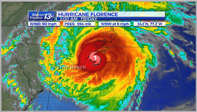
Hurricane Florence continues to slowly move towards the N. Carolina coast at 6 mph. It is still a Category 1 hurricane and observed wind gusts have been reported over 100 mph with wave heights of 30 feet offshore.
8 PM UPDATE:
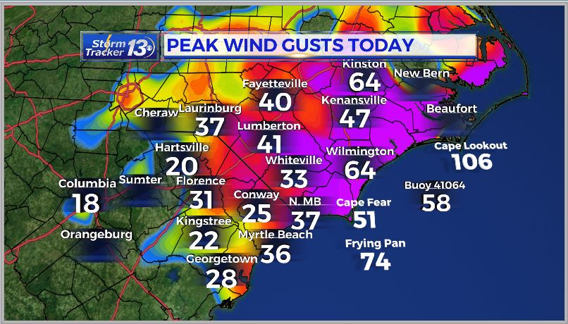
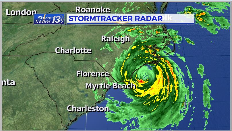
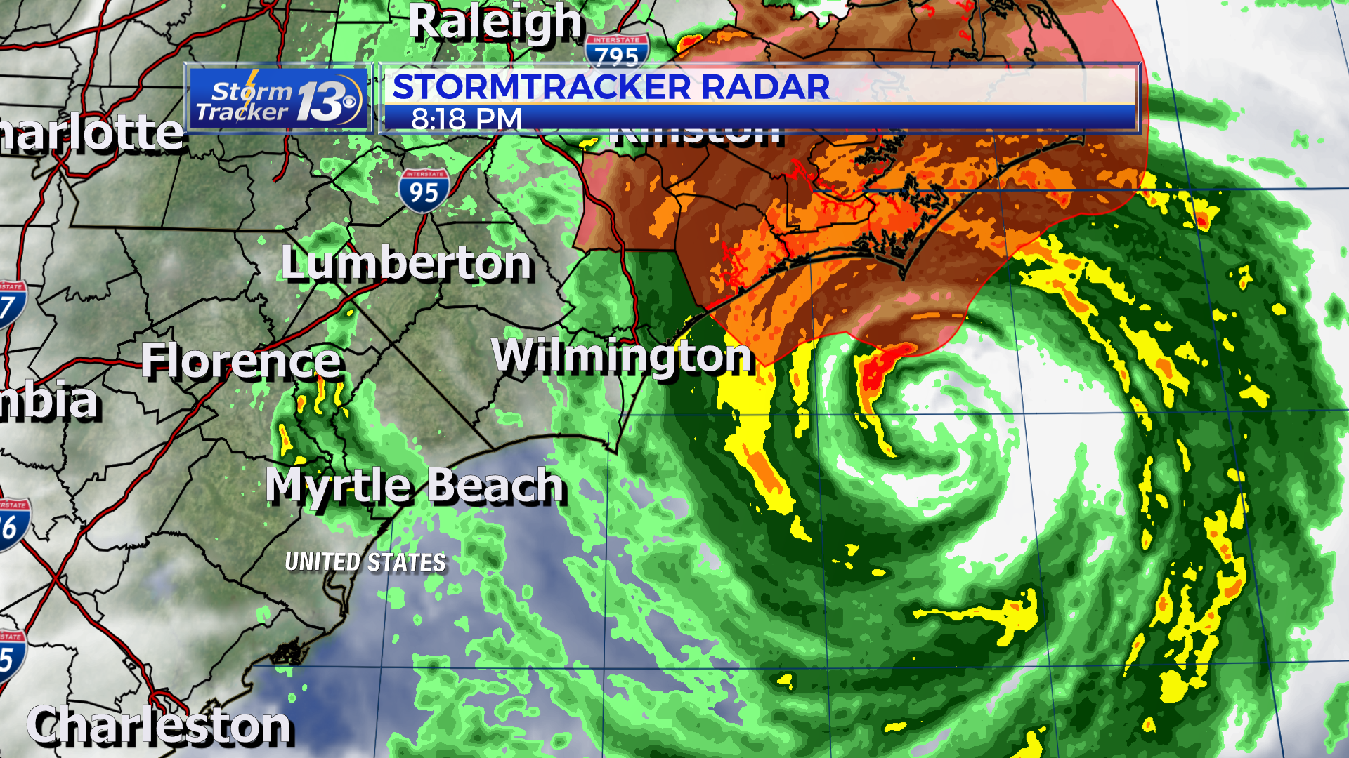
Sustained hurricane force winds are arriving to Cape Lookout in North Carolina and the southern end of the Outer Banks. Gusts are being reported over 100 mph offshore and wave heights are reaching up to 30 ft offshore. Sustained winds are at 100 mph in the eyewall of Florence with higher gusts. Rain bands are starting to move through our area as well.
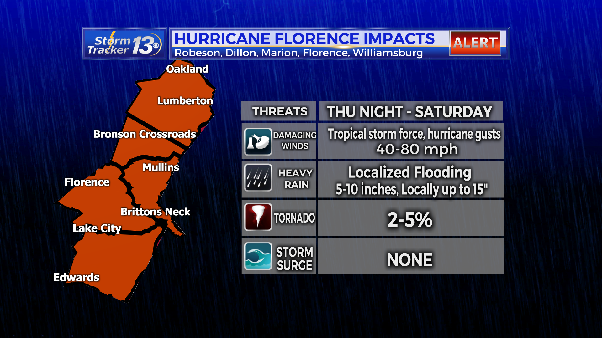
5 PM THURSDAY FLORENCE:
Florence continues to weaken and sustained winds are down to 100 mph.
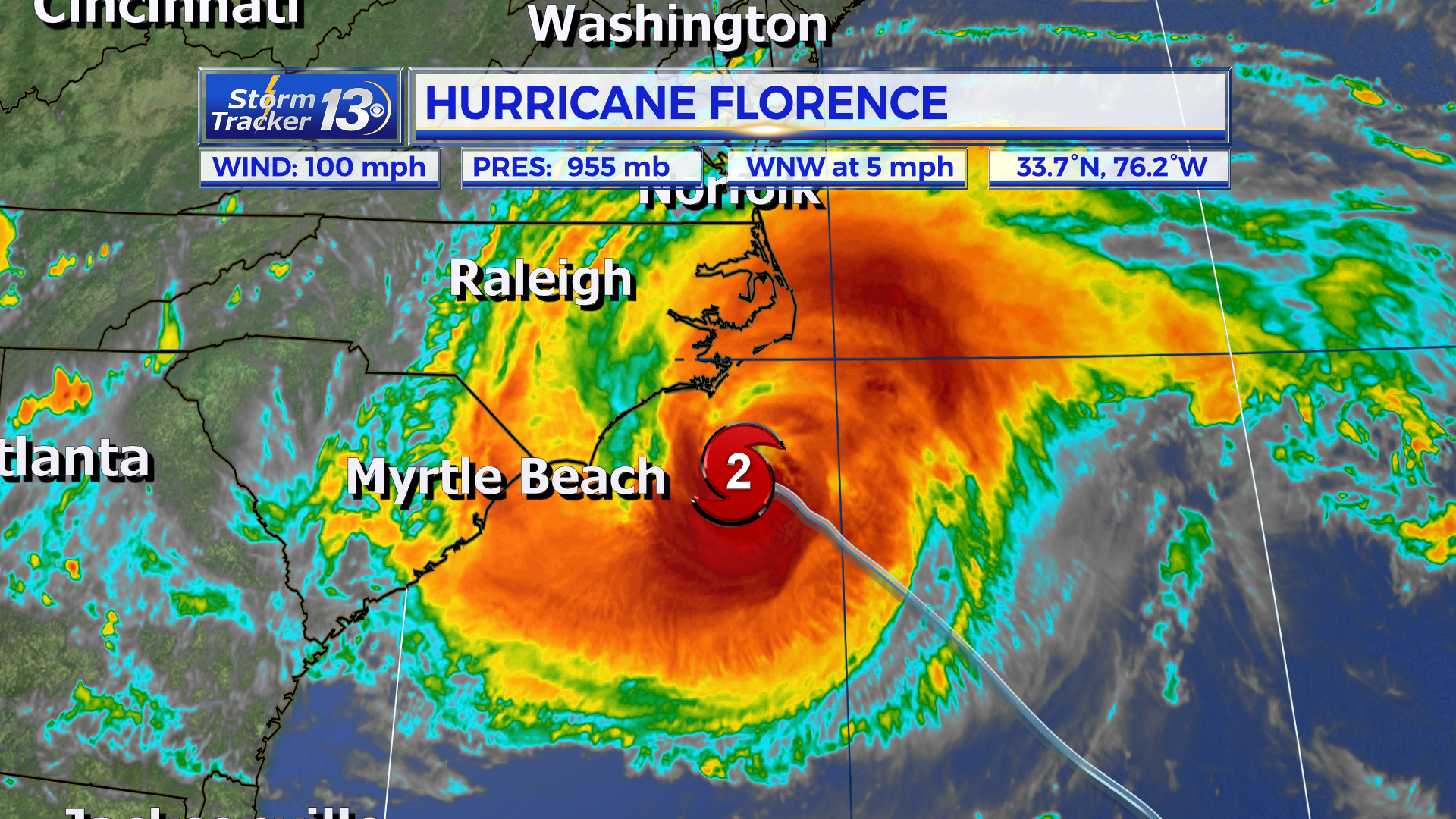
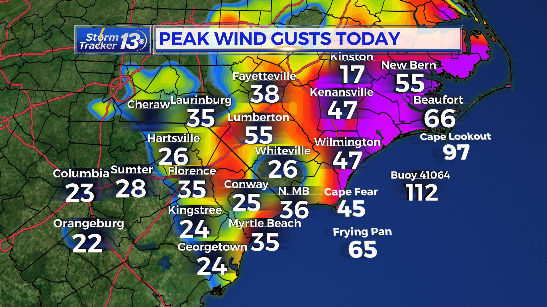
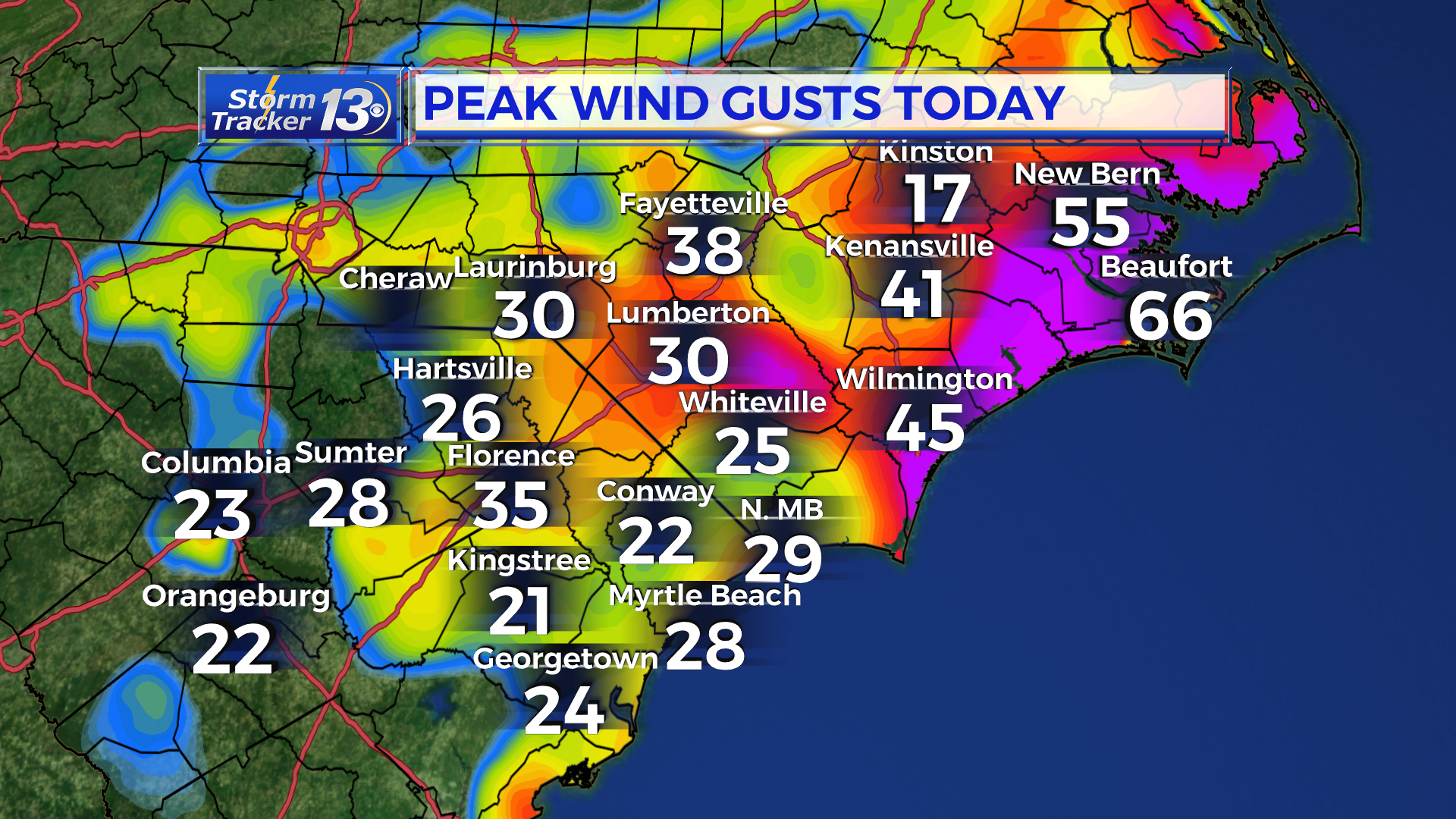
Winds are starting to pick up especially up across North Carolina near Moorehead City and the southern end of the Outer Banks. A few of the higher gusts we’ve seen come in have reached up to 66 in Beaufort, 51 mph in New Bern, a 45 mph in Wilmington with the gusts starting to pick up near North Myrtle Beach as well. The tropical storm force gusts will be moving into the eastern portions of Horry Co over the next couple of hours.
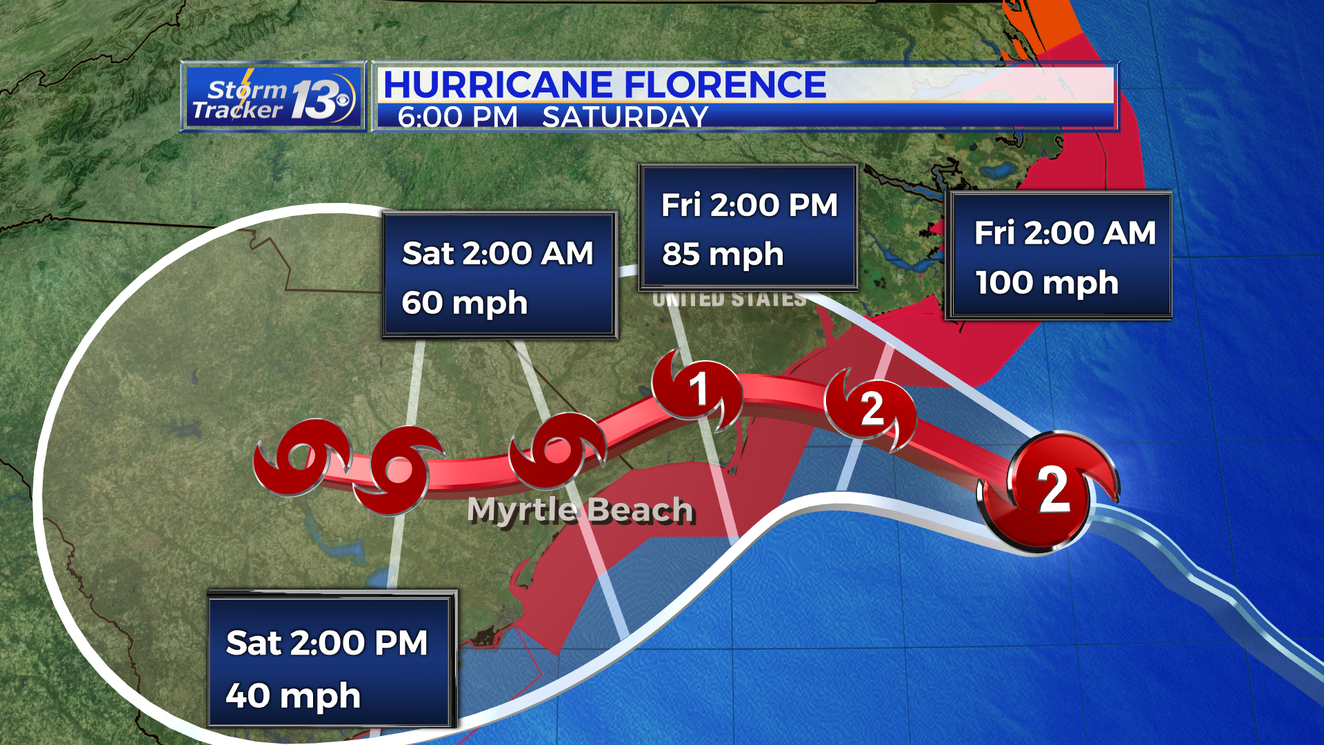
Conditions will deteriorate overnight tonight and in throughout the day tomorrow with winds steadily picking up. The storm has slowed and basically stalled about 150 miles east of Myrtle Beach. Florence will very slowly move towards the coast of North Carolina and is forecast to make landfall near Wilmington. If the storm takes a track farther to the south, the center will stay over water longer and the storm could hold its strength.
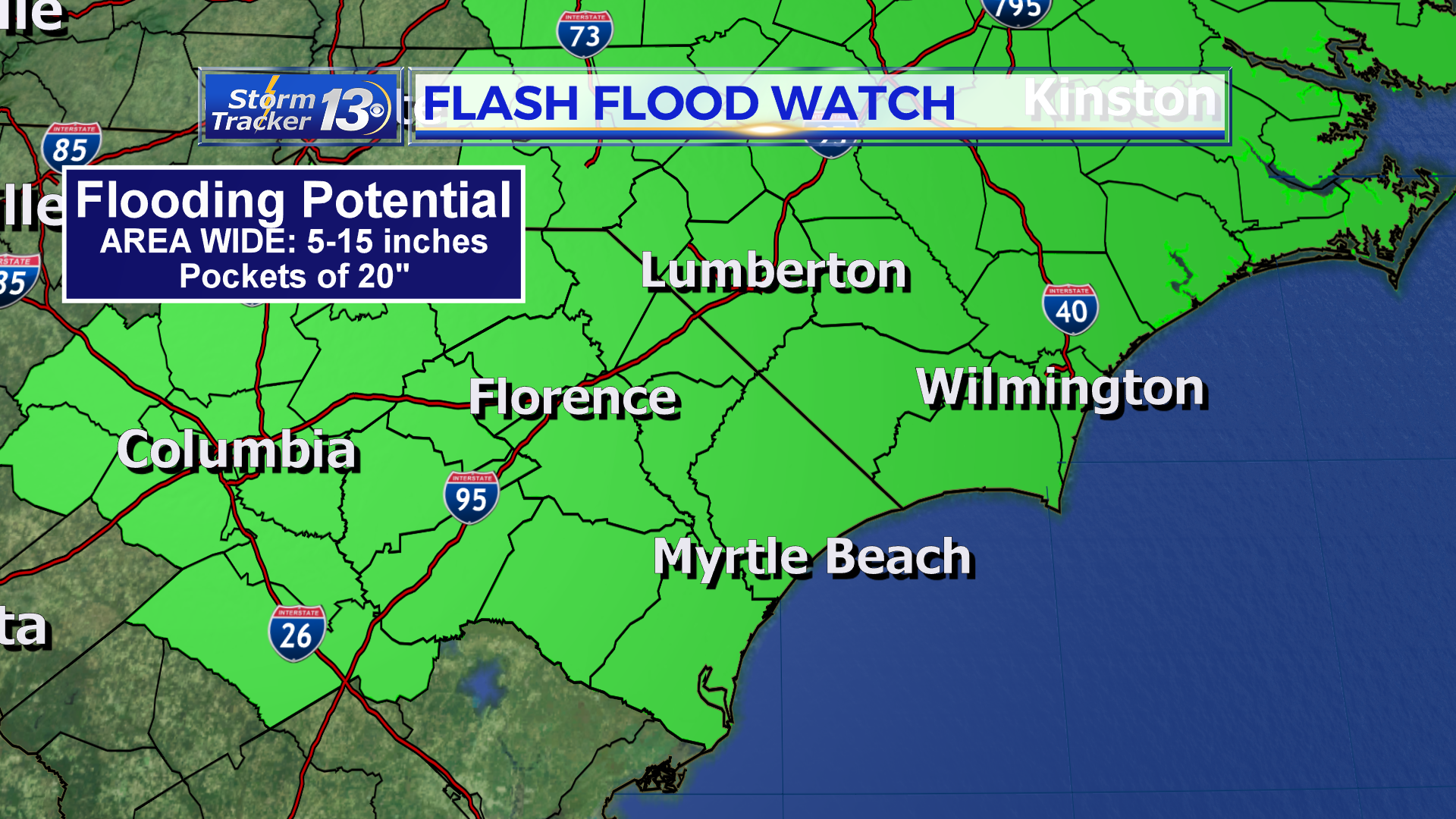
We’re still looking at a prolonged event with breezy and gusty winds continuing through Saturday. The rainfall potential is still our biggest concern. Area wide, we’re expecting 5-15 inches with isolated pockets of up to 20″. Even higher amounts will accumulate up in North Carolina and it could break numerous records.
3PM THURSDAY FLORENCE UPDATE:
Location: 33.6°N 76.1°W
Moving: WNW at 10 mph
Min pressure: 955 mb
Max sustained: 105 mph
11AM THURSDAY FLORENCE UPDATE:
Hurricane Florence continues to slowly weaken and is slowing down in forward motion. As of 11am, current sustain winds of 105mph, still at Cat 2 hurricane, moving northwest at 10mph. Forecast hasn’t changed. We are still expected landfall as a cat 2 hurricane in SE North Carolina sometime after midnight to early friday morning and then pushing southwest into South Carolina as a Cat 1 hurricane and then weakening Friday into a tropical storm.
8 AM THURSDAY FLORENCE UPDATE:
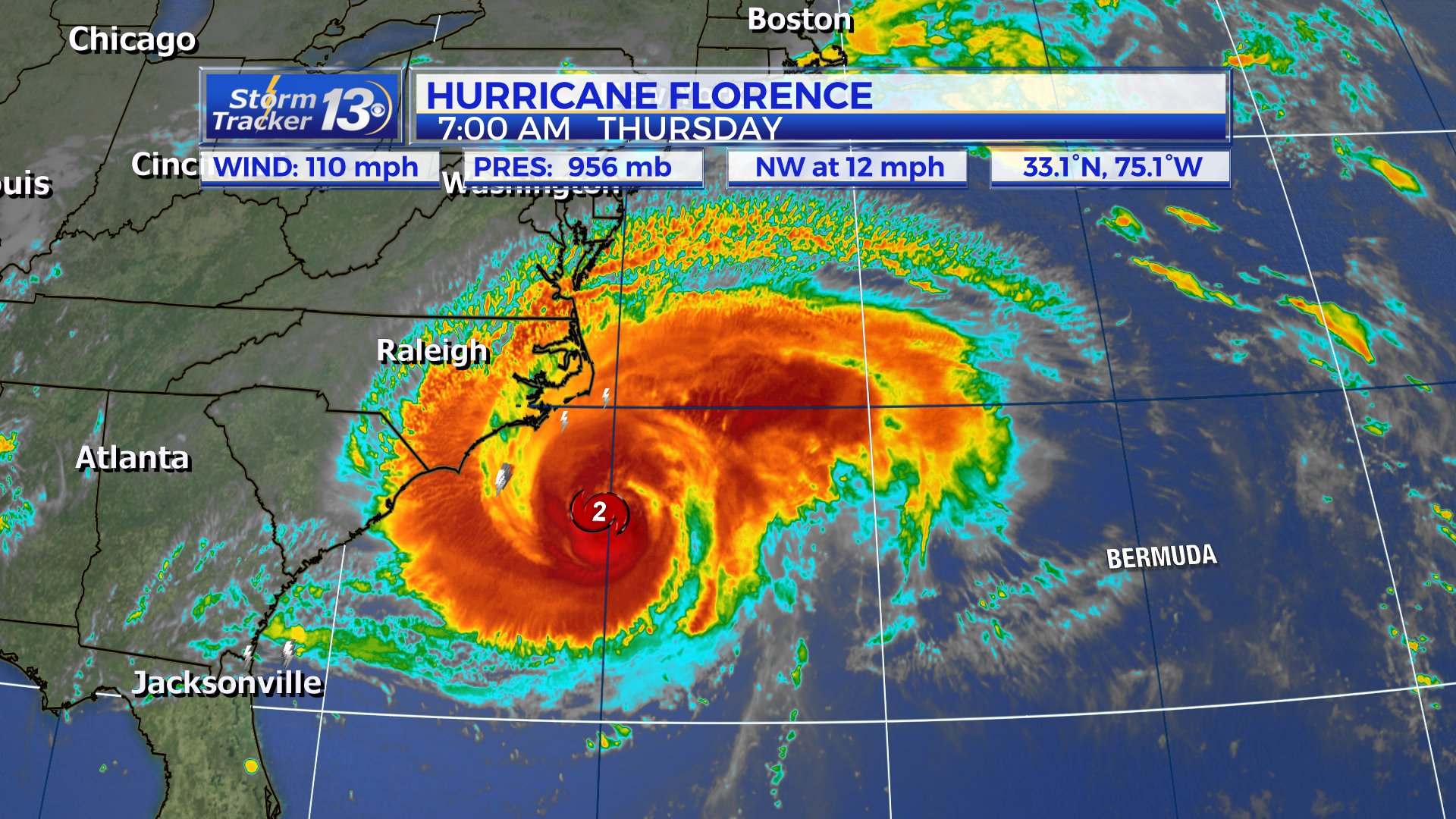
Florence outer bands making their way to parts of the Crystal Coast of NC and is slowing down forward speed as of 8am. Florence maintains Cat 2 statues with winds of 110mph, moving northwest at 12mph. Florence went through another eyewall replacement cycle, which could indicate a strengthening. However, not much is expected and whether or not Florence strengthens or weakens, there will still be life threatening storm surge northeast of the center, along with damaging hurricane force winds and then heavy rain that could lead to flooding.
5 AM THURSDAY UPDATE:
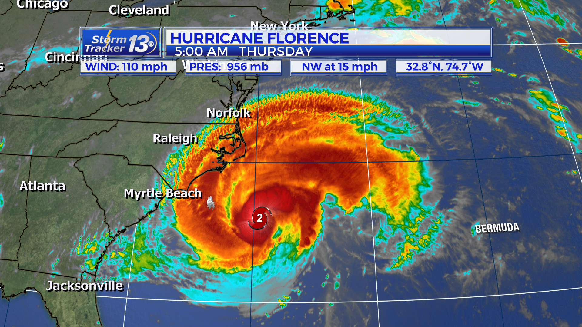
Outer bands of Florence are approaching coast of North Carolina. Florence has slowed down a tad,now moving NW at 15mph with sustained winds at 110mph.
11 PM FLORENCE UPDATE:
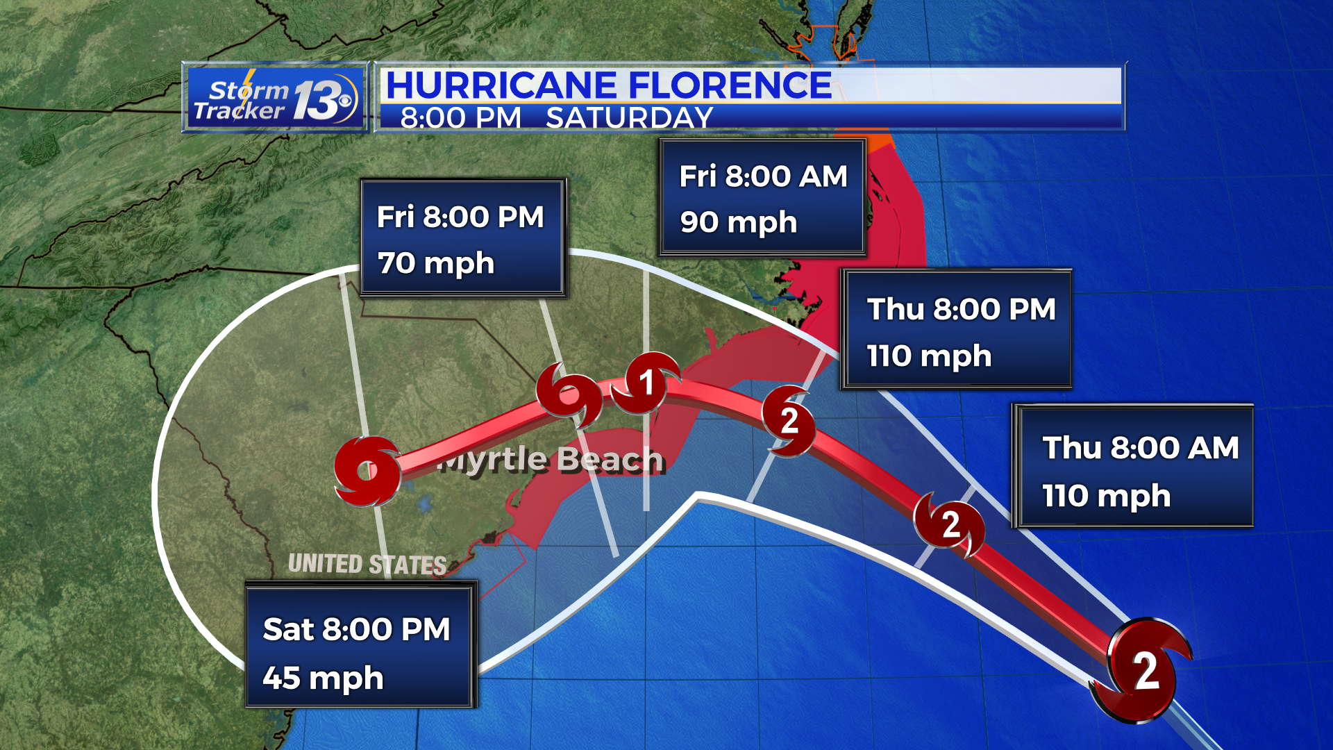
Hurricane Florence weakened further this afternoon and is not a strong category 2 with sustained winds of 110 mph. Movement is still fast at 17 mph to the NW but this will slow towards morning and especially tomorrow afternoon.

The track still slows the storm to a crawl just before landfall and we’re still expecting devastating impacts to the beaches as well as potentially life-threatening storm surge. The storm may be slightly weaker but the over all forecast has not changed. Florence will come ashore somewhere just across the border before taking a sharp turn to the SW.
8 PM FLORENCE UPDATE:
Sustained winds have decreased some to 115 mph, however Florence remains a very powerful major category 3 hurricane. Movement is expected to slow as it moves towards the coast tonight and then the storm will take its sweet time moving ashore. The faster it moves ashore, the faster we see a weakening hurricane, and vice versa. The 5 pm update below still stands; we’ll get another cone update at 11 pm tonight.

5 PM WEDNESDAY FLORENCE UPDATE
Florence remains a strong category 3 storm with sustained winds of 120 mph. Movement is still quick to the NW at 16 mph. The physical structure of the storm is not as impressive this evening with a ragged looking eye. A small amount of strengthening is possible still as it moves over the very warm waters of the Gulf Stream.
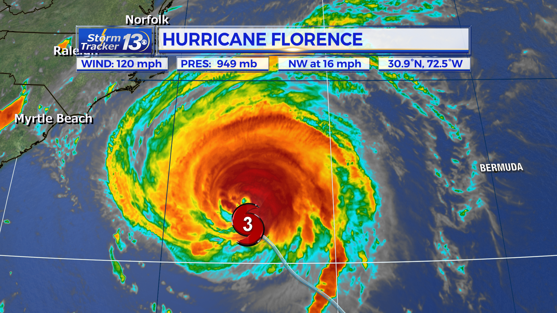
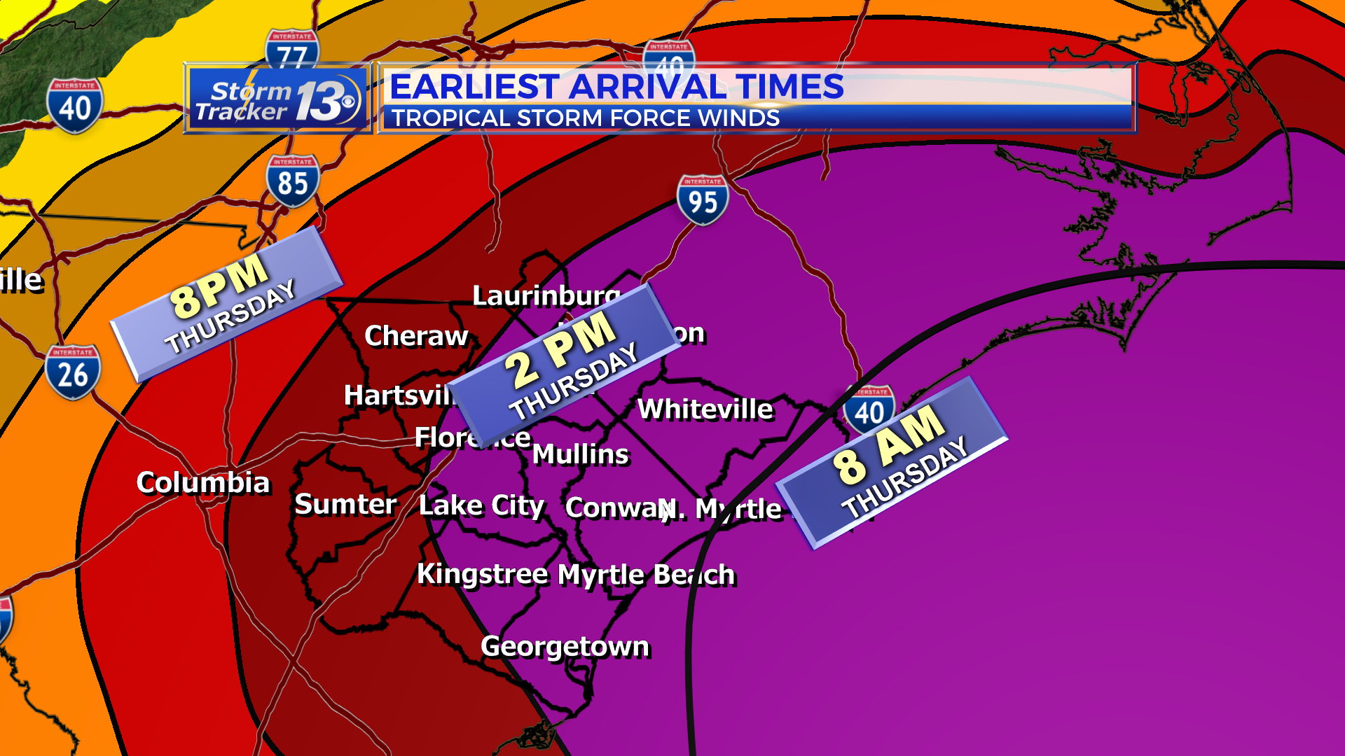
The latest track has changed little. Florence will continue NW overnight and the center will be about 250 miles off the coast by 2 am Thursday morning. At this time Florence will slow down and stall out for almost a whole day. Tropical storm conditions will arrive by Thursday morning to the Grand Strand and Thursday evening to our counties west of I-95.
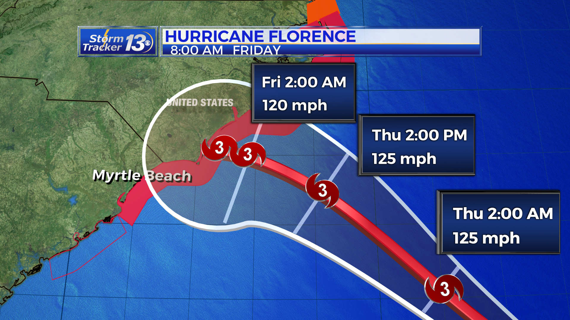
Conditions will gradually worsen as Florence slowly moves inland and jogs to the southwest, possibly following the coastline and maintaining some strength. Finally, condition should begin to improve by Sunday as the storm starts to pull away from the Carolinas and moves in to the upstate.

IMPACTS:
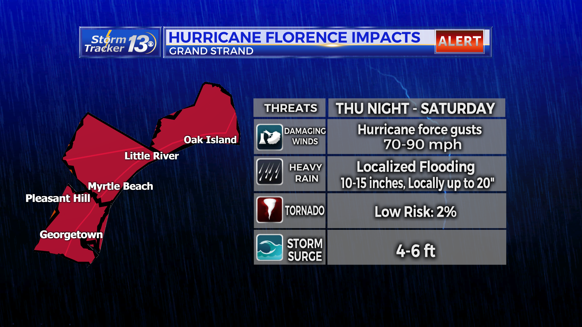
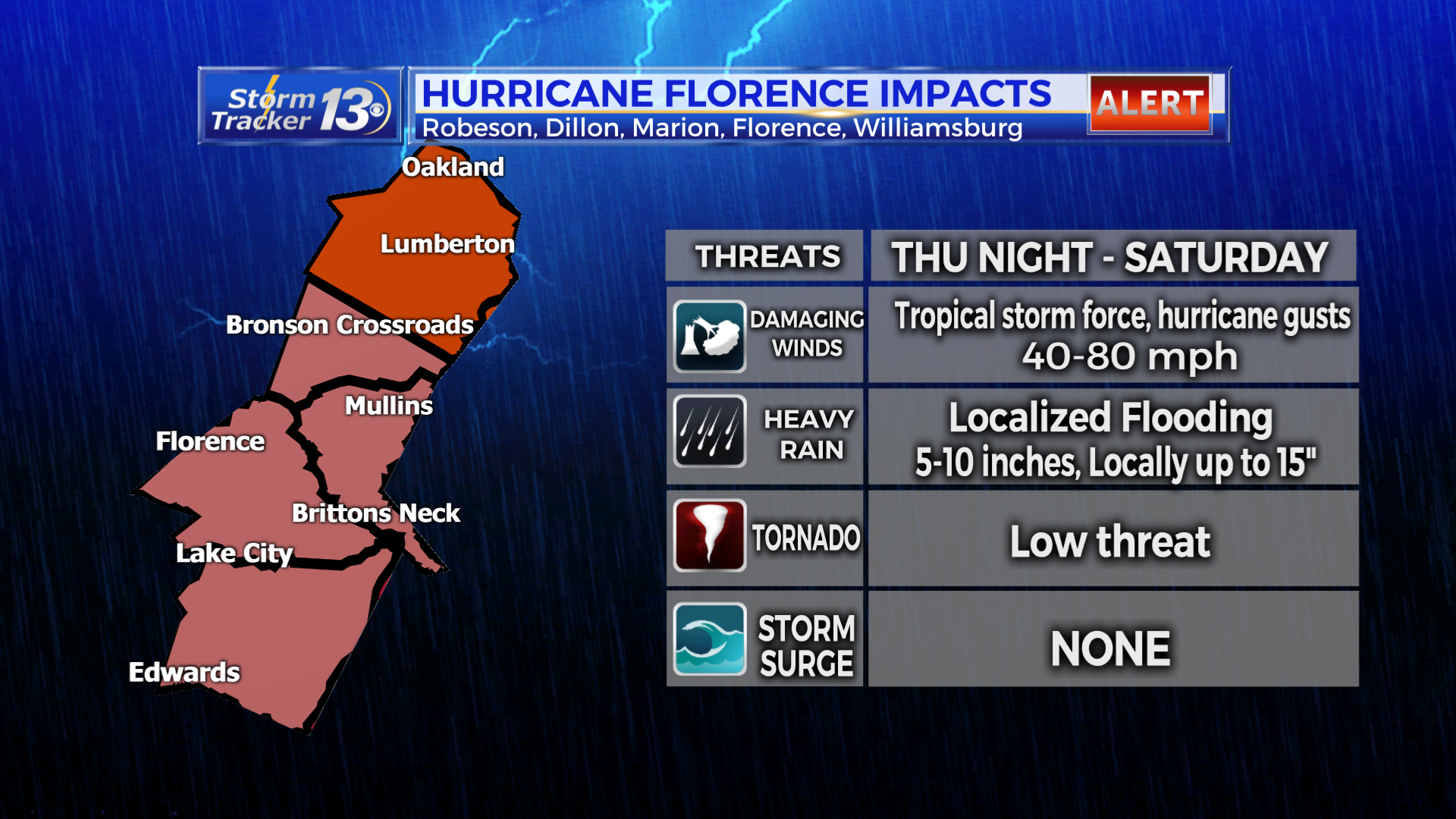
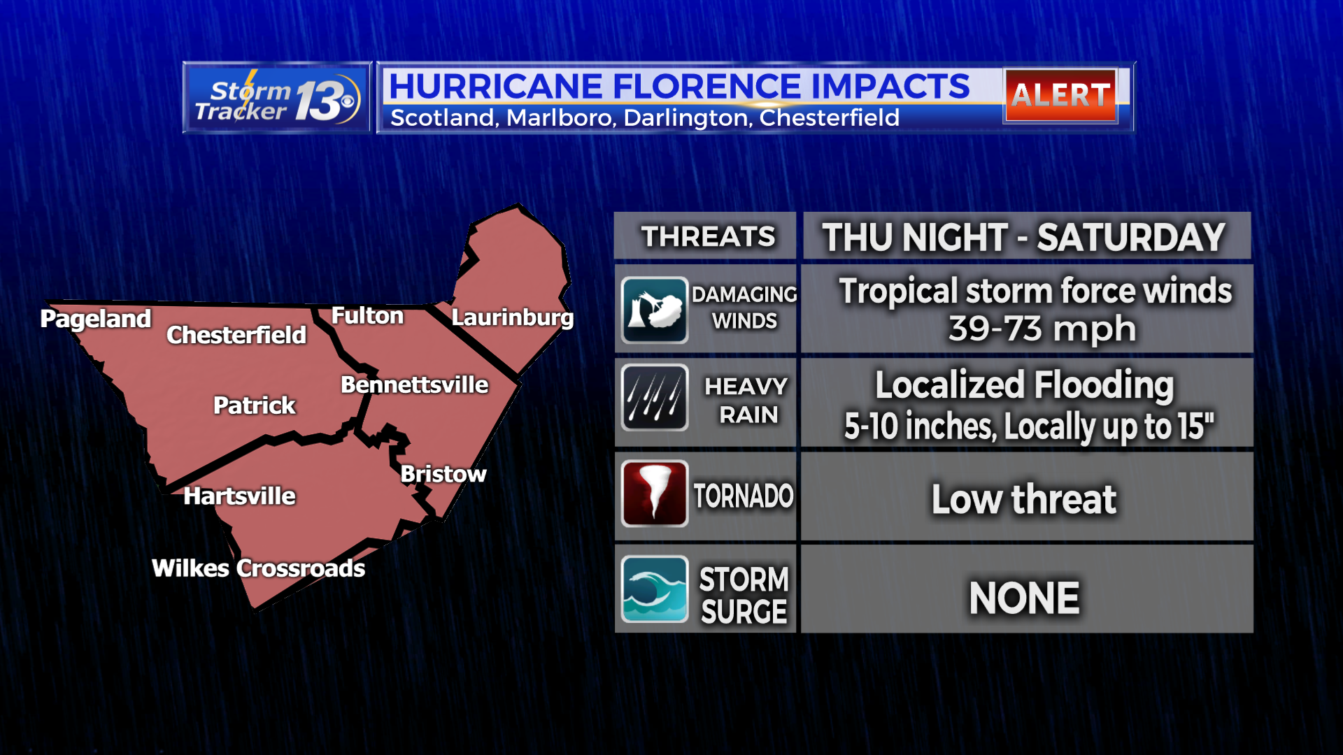
Wind Threat: Everyone in the Eastern Carolinas can expect to at least feel winds up to 73 mph, or tropical storm force winds. The Grand Strand and a few folks just inland of Horry and Georgetown Counties have a pretty good chance of seeing hurricane force winds, winds above 74 mph.

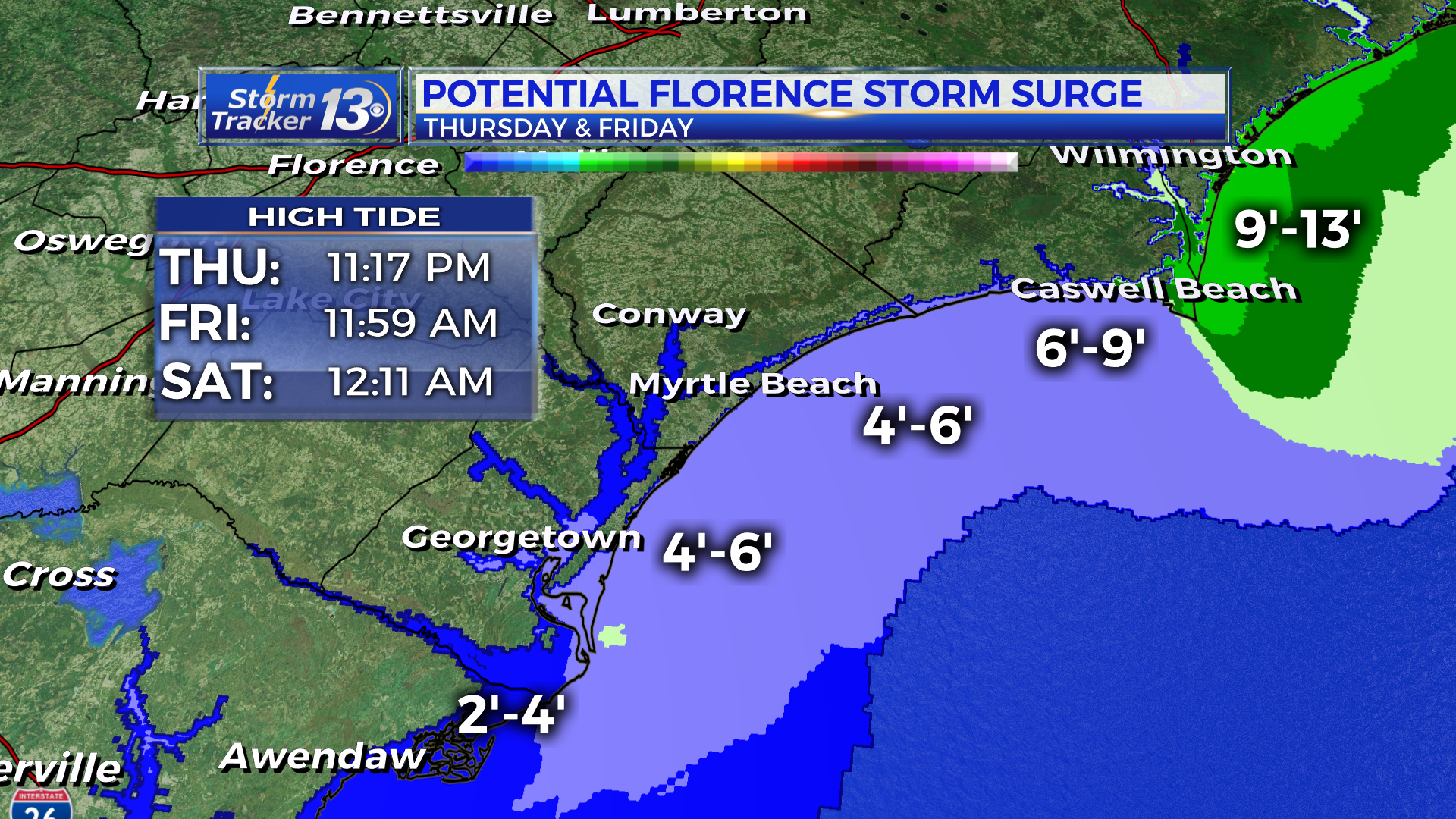
Storm surge forecasts remain largely the same with the potential to see 4-6 ft along the Grand Strand. North of the border, 6-9 ft is possible up through Cape Fear and north of Cape Fear, water could be as high as 9-13 ft at the high tides.
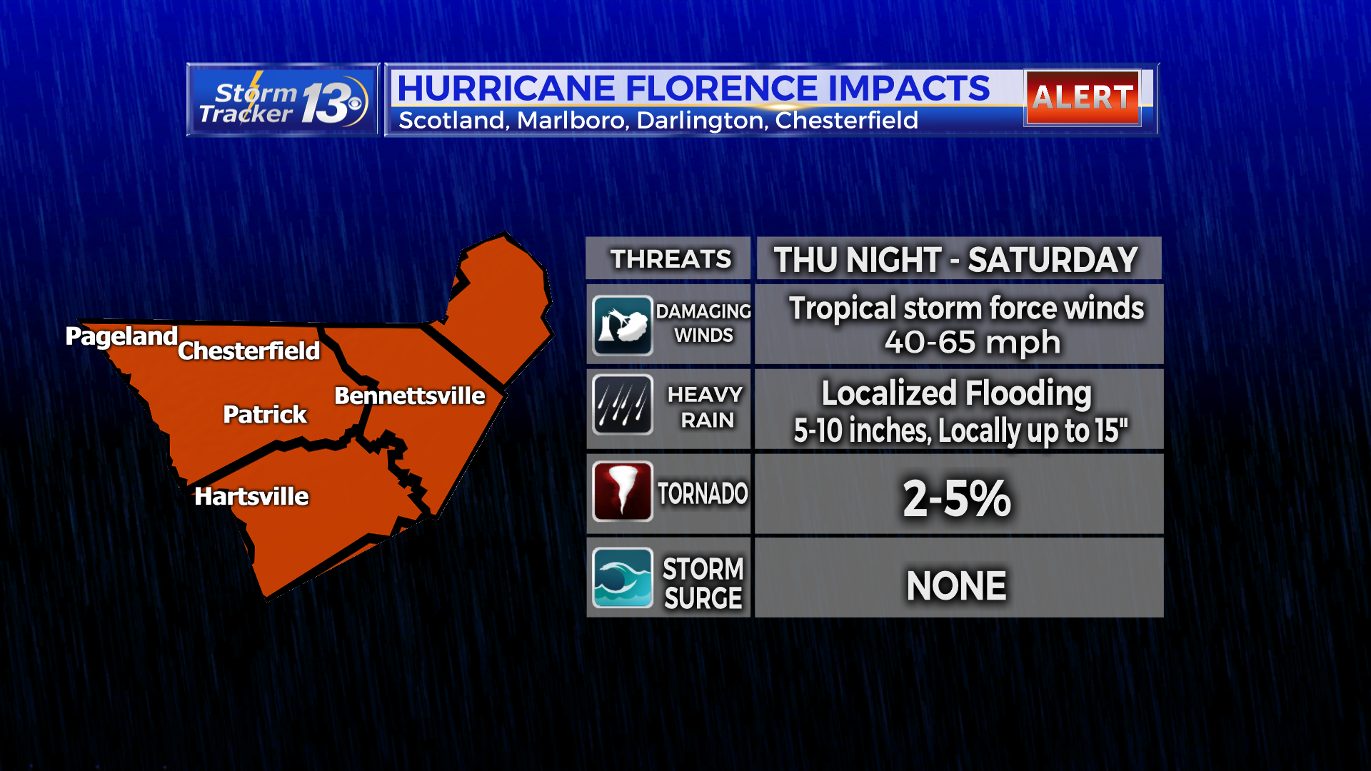
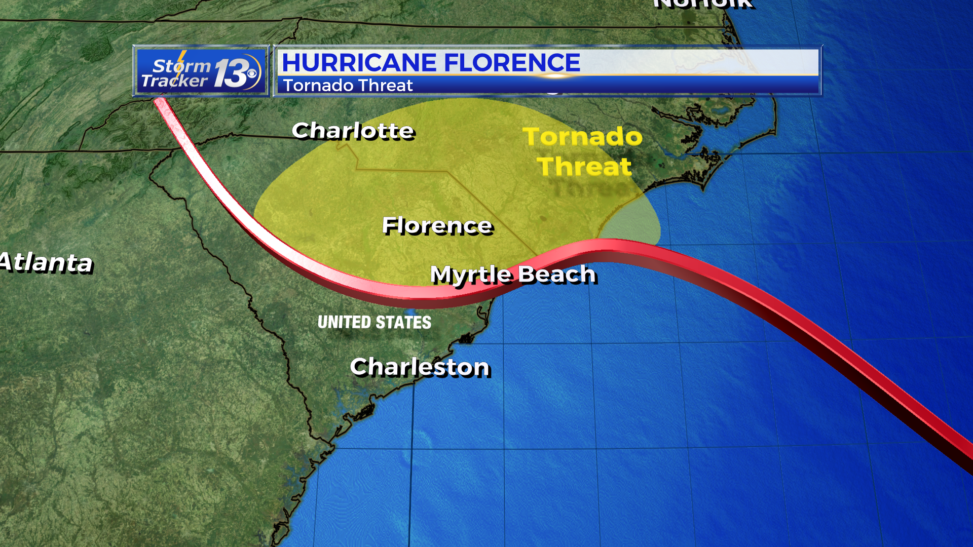
Tornado threat: A low threat exists for Dillon, Marion, Darlington, Florence, Chesterfield, Marlboro, Scotland and Robeson Counties while the center of the storm is near the Grand Strand.
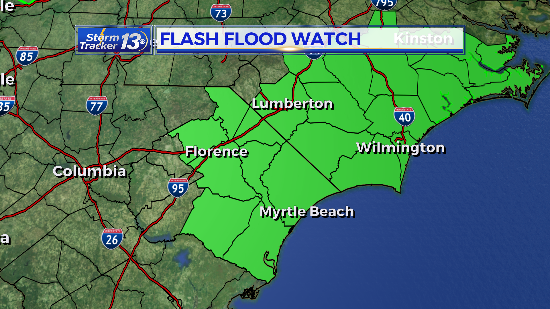
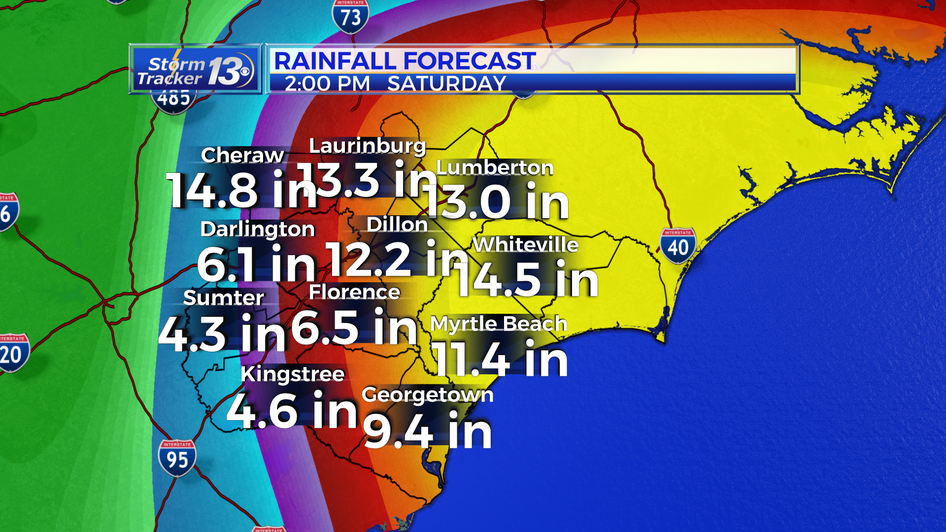
Rainfall: With the current track, flooding is becoming more of a concern for the Grand Strand, Pee Dee and the Upstate of SC. Forecast models have anywhere between 6 inches of rain to 13 inches of rain for our area. Pockets of higher amounts, possibly up to 20″, are possible but will be impossible to pin point where the higher totals will accumulate. A Flash Flood Watch remains in effect for this reason.
3 PM FLORENCE WEAKENS
Hurricane Florence has weakened slightly as of the 2pm intermediate advisory. Winds speeds are down to 125 mph and it is a category 3 storm. It is expected to strengthen again before approaching our coast. Regardless, Florence will be a dangerous hurricane and could bring significant damage to our area. Another forecast track will come out at 5 but huge changes are not expected with the most recent model runs coming in.
The forecast as it stands is still the same as below.
11AM HURRICANE FLORENCE UPDATE:
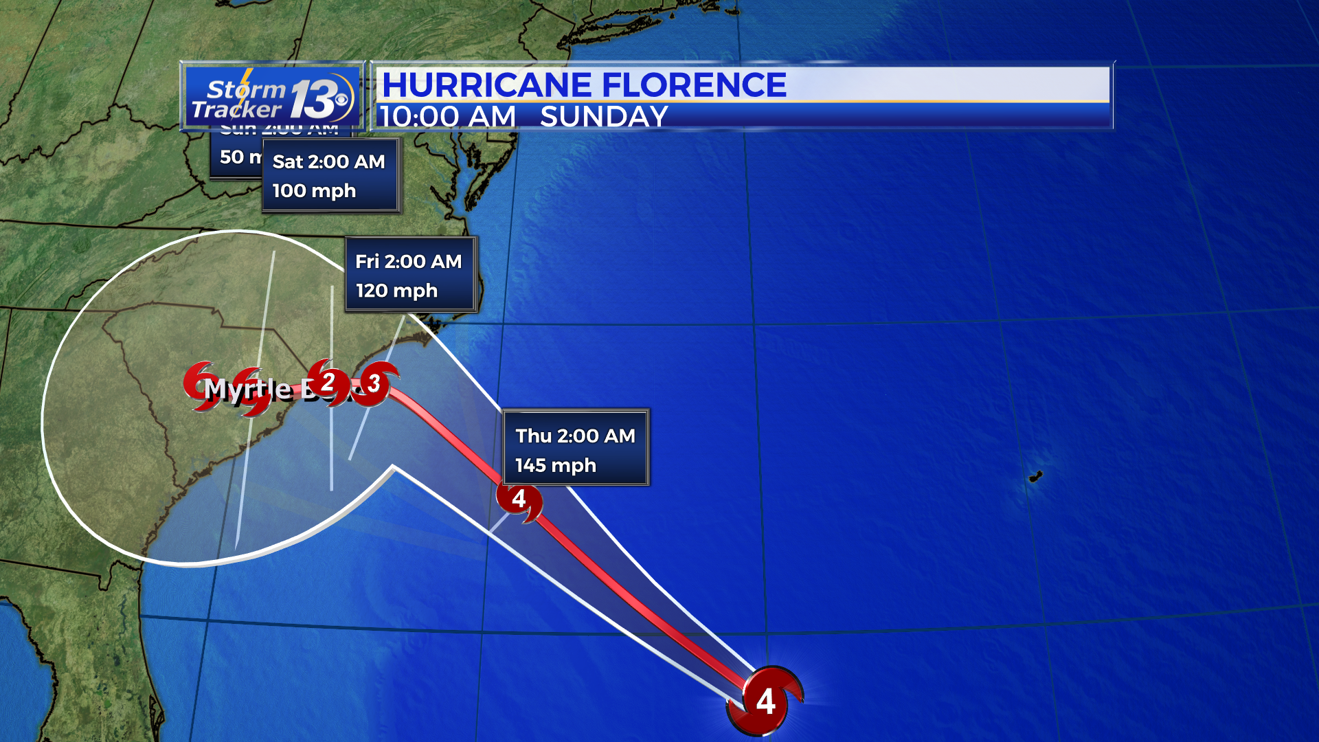
The forecast track with Florence continues to bring it close to the coast of the Carolinas. Models have continued a southwest track. Right now, Florence is expected to race towards the Carolina coast at 15 mph and then come to a slow craw turning southwest. The latest NHC track takes Florence as a major hurricane near the SC/NC border, and then turning southwest into SC.
Impacts are going to be felt all across the Carolinas.
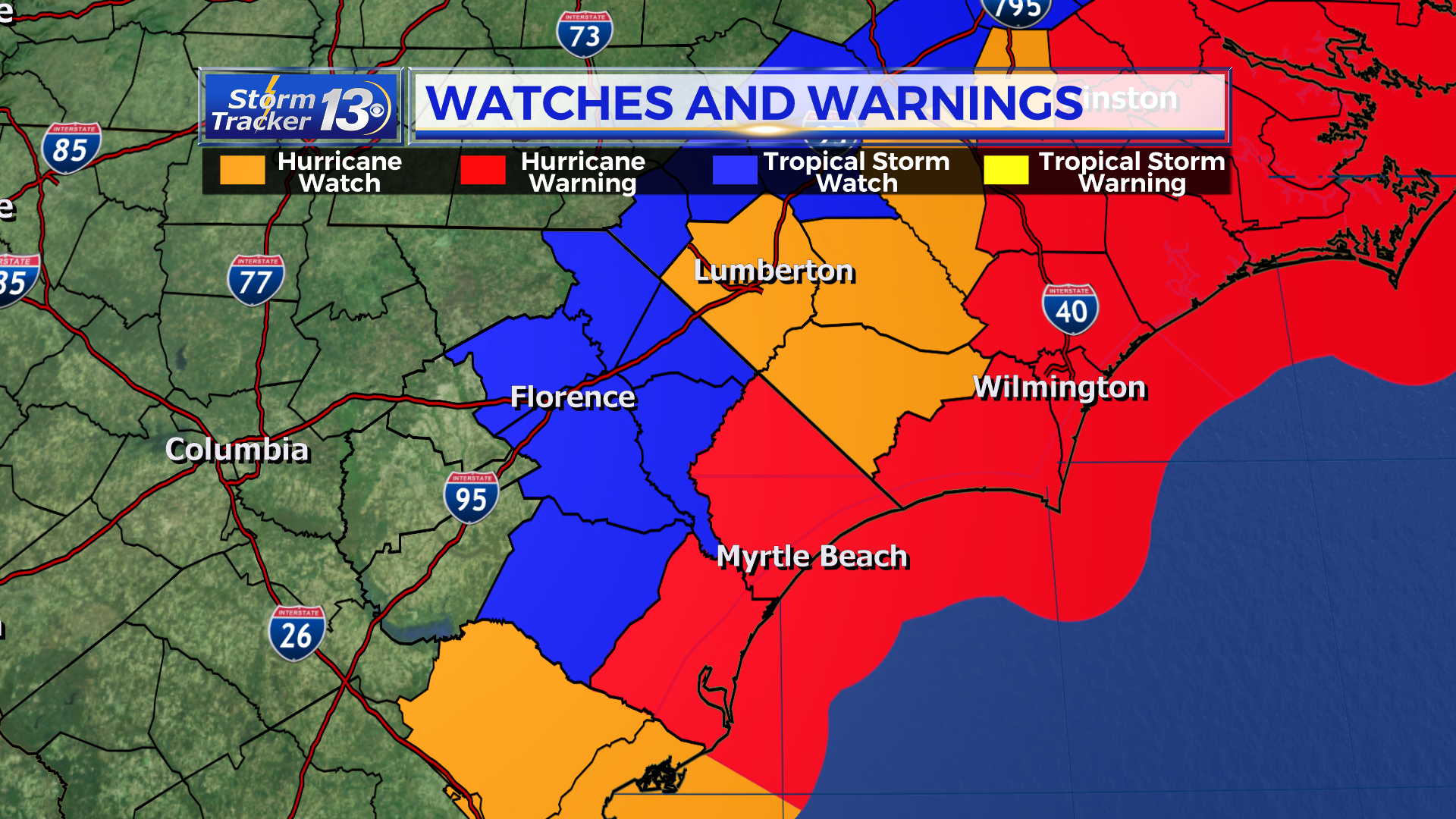
Tropical Storm Watches have been extended inland with the latest update.
Wind threat is increasing just a bit. We are expected sustained winds up to tropical storm force across the area. But there will be hurricane force gust from the coast to parts of the Pee Dee and Boarder Belt.
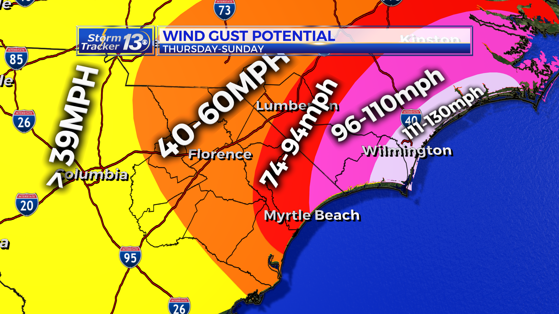
Storm surge forecasts remain largely the same with the potential to see 4-6 ft along the Grand Strand. North of the border, 6-9 ft is possible up through Cape Fear and north of Cape Fear, water could be as high as 9-13 ft at the high tides.

The tornado threat remains low for us as long as we stay south of where the center comes ashore.
Rainfall: With the shift in the track, flooding is becoming more of a concern for the Grand Strand, Pee Dee and the Upstate of SC. Forecast models have anywhere between 6 inches of rain to 13 inches of rain for our area.

8AM HURRICANE FLORENCE UPDATE:
The real big difference this morning with Florence is the forecast track. Models have continued a southwest track. Right now, Florence is expected to race towards the Carolina coast and then come to a slow craw turning southwest. As we have been saying this whole time, don’t focus so much on the center line. The latest NHC track takes Florence as a major hurricane near the SC/NC border, and then turning southwest into SC.

Impacts are going to be felt all across the Carolinas.
Tropical Storm Watches have been extended inland with the latest update.

Wind threat is increasing just a bit. We are expected sustained winds up to tropical storm force across the area. But there will be hurricane force gust from the coast to parts of the Pee Dee and Boarder Belt.

Storm surge forecasts remain largely the same with the potential to see 4-6 ft along the Grand Strand. North of the border, 6-9 ft is possible up through Cape Fear and north of Cape Fear, water could be as high as 9-13 ft at the high tides.

The tornado threat remains low for us as long as we stay south of where the center comes ashore.
Rainfall: With the shift in the track, flooding is becoming more of a concern for the Grand Strand, Pee Dee and the Upstate of SC. Forecast models have anywhere between 6 inches of rain to 13 inches of rain for our area.

5AM WEDNESDAY UPDATE:
Hurricane Florence continues as a very powerful Cat 4 hurricane with winds of 130mph. Florence is moving west-northwest at 17mph. Pressure is down to 946mb this morning.
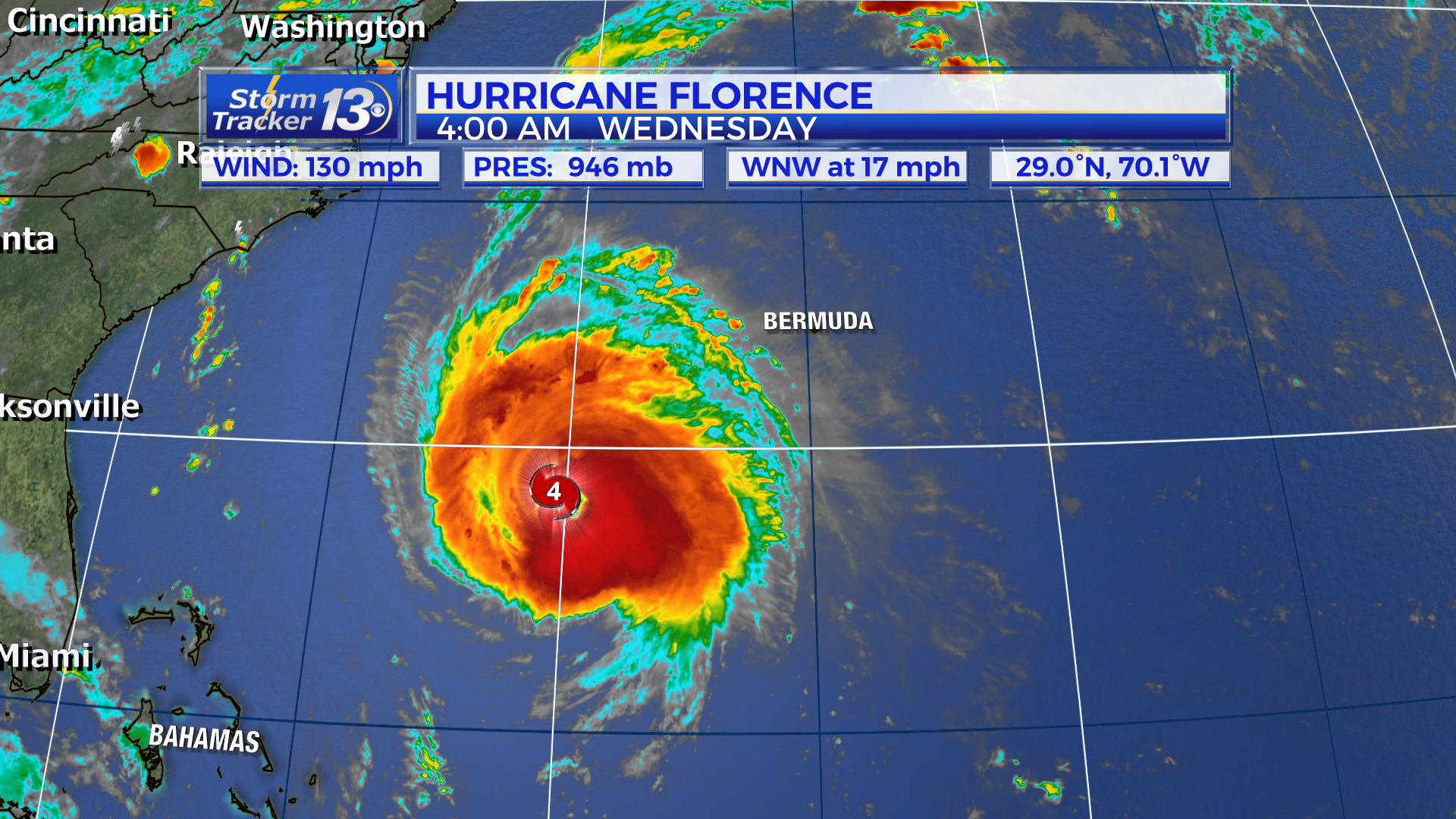
The real big difference this morning with Florence is the forecast track. Models have continued a southwest track. Right now, Florence is expected to race towards the Carolina coast and then come to a slow craw turning southwest. As we have been saying this whole time, don’t focus so much on the center line. The latest NHC track takes Florence as a major hurricane near the SC/NC border, and then turning southwest into SC.

Impacts are going to be felt all across the Carolinas.
Tropical Storm Watches have been extended inland with the latest update.

Wind threat is increasing just a bit. We are expected sustained winds up to tropical storm force across the area. But there will be hurricane force gust from the coast to parts of the Pee Dee and Boarder Belt.

Storm surge forecasts remain largely the same with the potential to see 4-6 ft along the Grand Strand. North of the border, 6-9 ft is possible up through Cape Fear and north of Cape Fear, water could be as high as 9-13 ft at the high tides.

The tornado threat remains low for us as long as we stay south of where the center comes ashore.
Rainfall: With the shift in the track, flooding is becoming more of a concern for the Grand Strand, Pee Dee and the Upstate of SC. Forecast models have anywhere between 6 inches of rain to 13 inches of rain for our area.

11 PM FLORENCE UPDATE:
Changes: Sustained winds are still sitting at 140 mph and Florence continues WNW at 17 mph. In other words, no chances in intensity. Tropical storm force winds extend out 175 miles from the center and hurricane force winds (74+ mph) extend out 60 miles each way. The biggest change today are the models have Florence stalling and meandering over the Carolinas through the weekend. This could potentially bring a larger flooding threat than originally thought. Currently the confidence is low on this and the forecast details will need to be looked at carefully over the coming days. The timing has shifted a little today as well with the latest forecast not having Florence make landfall until late Thursday night.
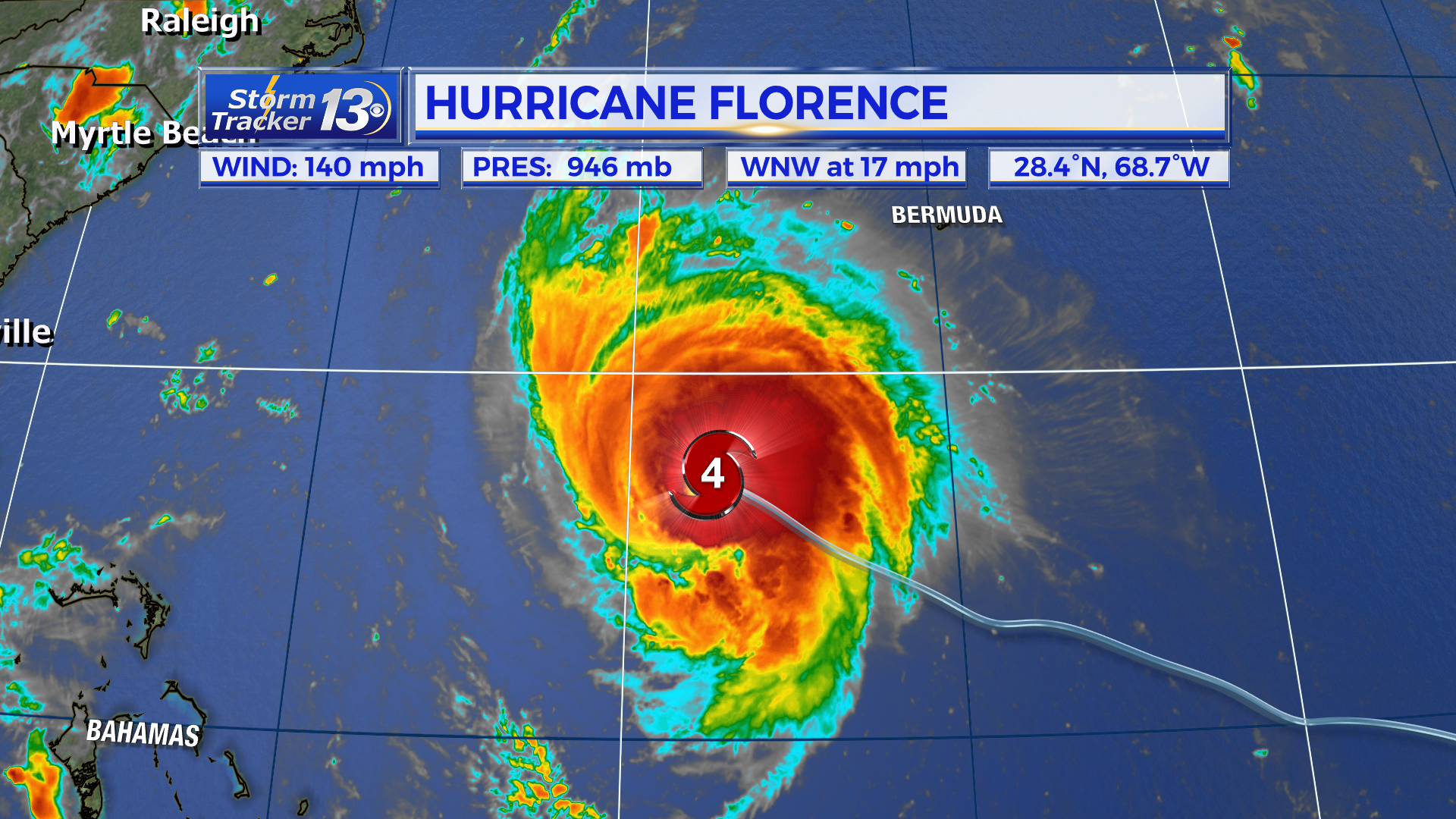
Tropical Storm Watches have been extended inland with the latest update.

Track: The 11pm track has been nudged to the left a little as it approaches land. It is important NOT to focus on the center of the cone because Florence could still make landfall anywhere inside the cone. This evening’s models have decreased our certainty with the latest shifts.
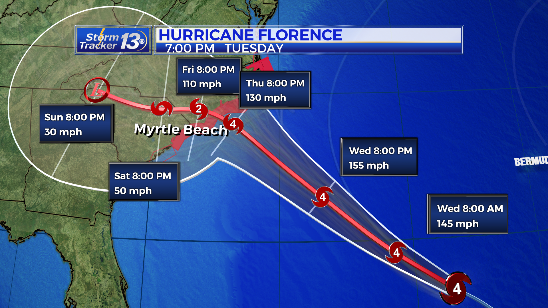
For now, Florence will continue on WNW overnight and in through the day on Wednesday at the same speed. The latest track has Florence at peak intensity on Wednesday during the afternoon at 155 mph. After this, Florence will continue bee-lining towards the Carolina coastline approaching by Thursday midday as a powerful category 4 storm with winds of 130 mph. At this time, Florence is forecast to slow down considerably. This could be very bad news for our beaches as Florence will take almost 24 hours to move inland.
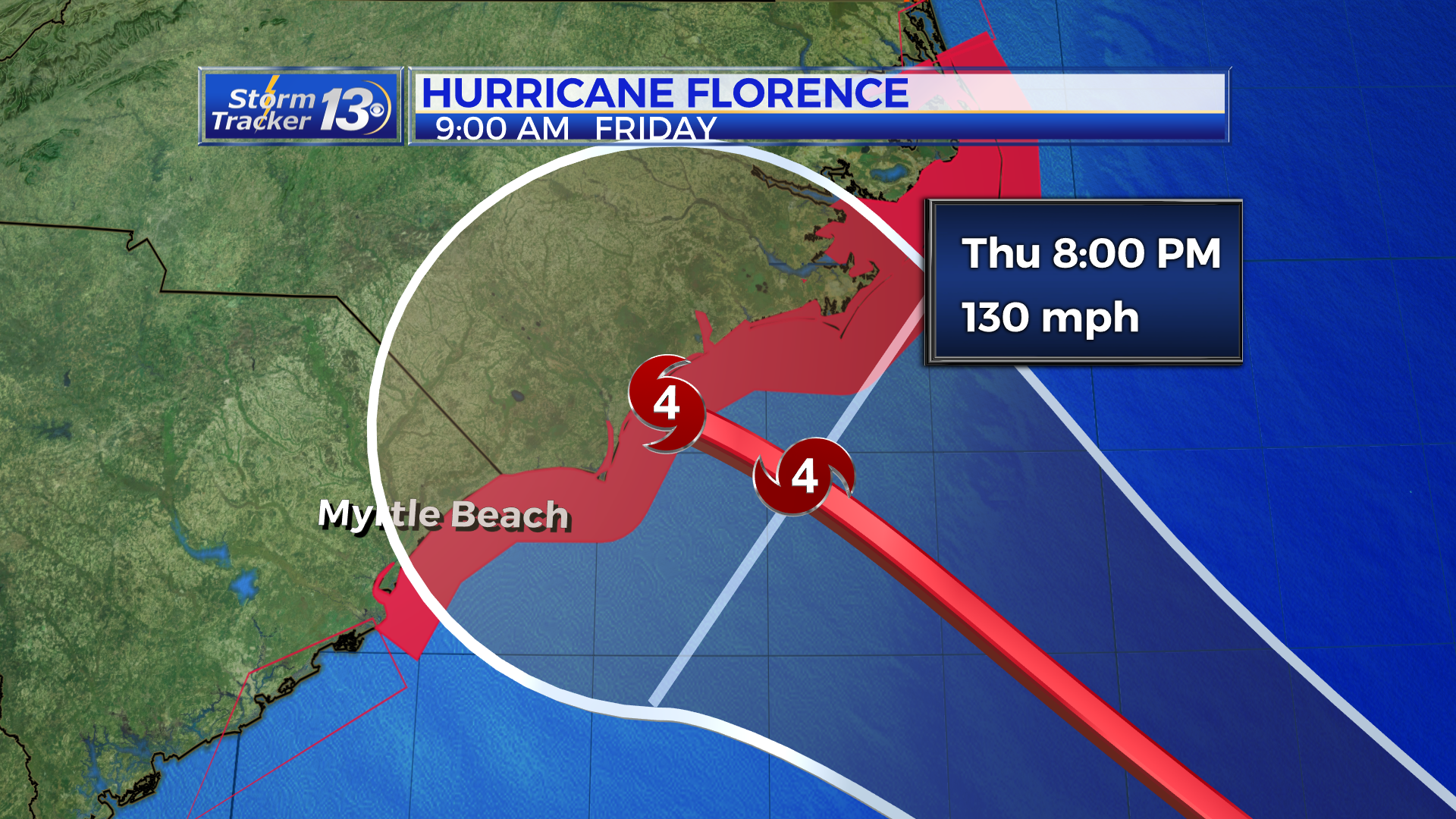
We will start to see conditions deteriorate Thursday as the storm nears the Carolinas even though it may not be until Thursday night or early Friday morning until landfall. With the slow forward progression of the storm, tropical storm or hurricane conditions could be felt for a couple days. The new cone of uncertainty has Florence moving inland and meandering to the south through Sunday. This could mean rain could fall for several days across the Carolinas.
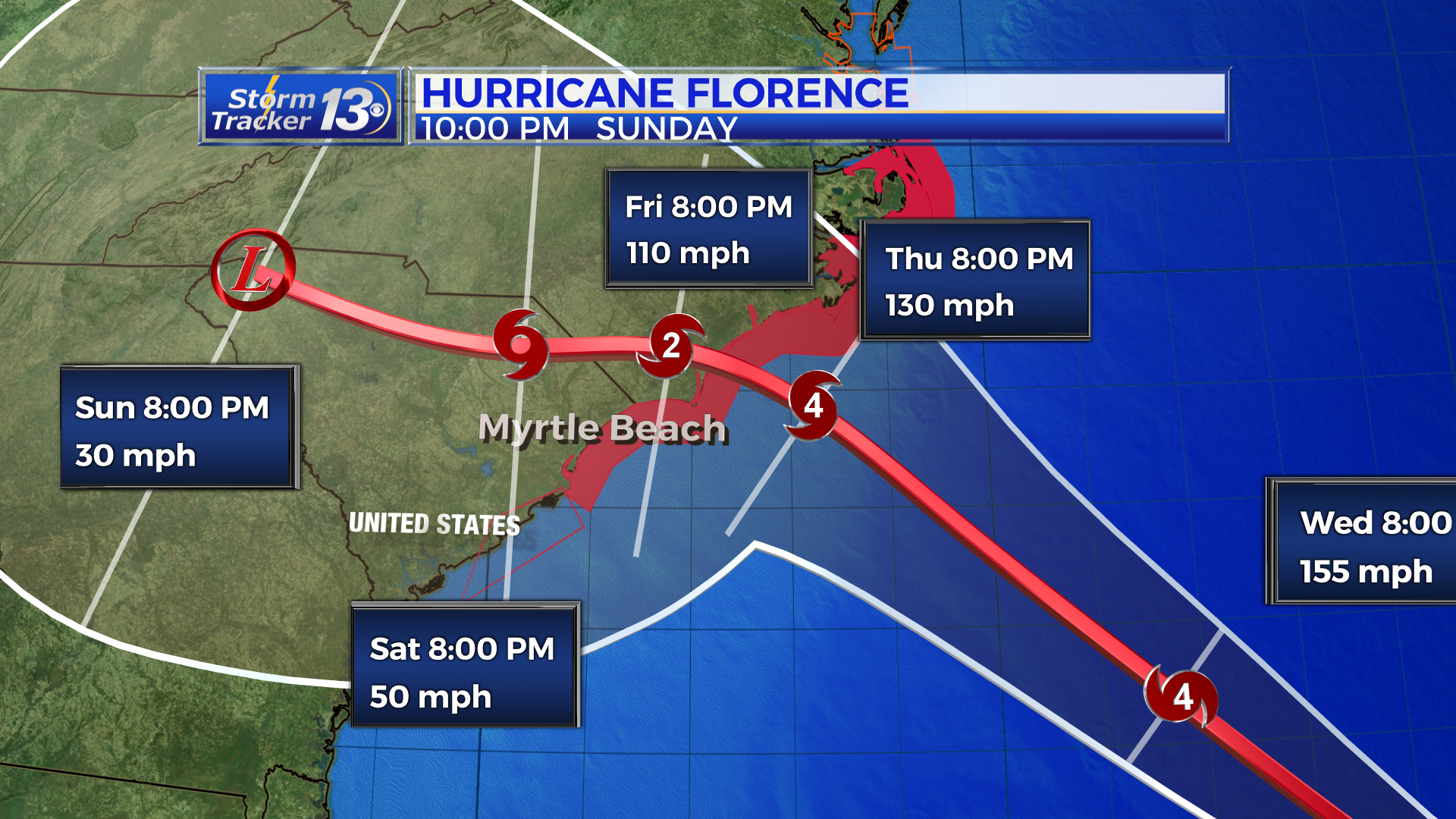
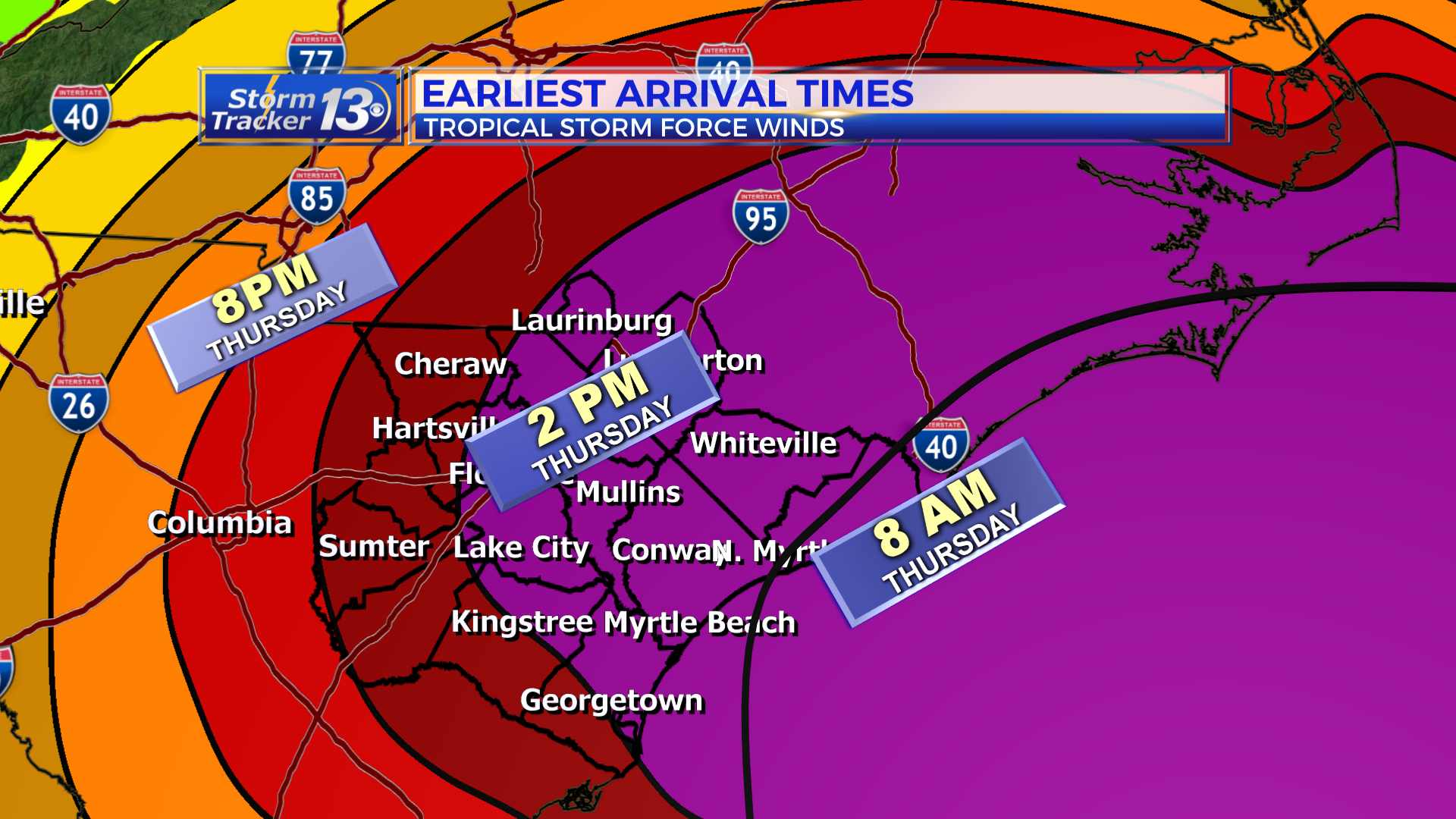
Impacts: The earliest arrival of tropical storm force winds (39-73 mph) to the coast is early Thursday morning. There is now a 100% chance of seeing tropical storm force winds along most of the Grand Strand and in cities along the NC/SC border. See the graphic below. This would include Horry, Dillon, Marion, Marlboro, Scotland, Robeson Co. and a 90% chance in Florence, Darlington, Chesterfield and Georgetown Co.

The chance to hurricane force winds has increased slightly as well with the latest forecast.
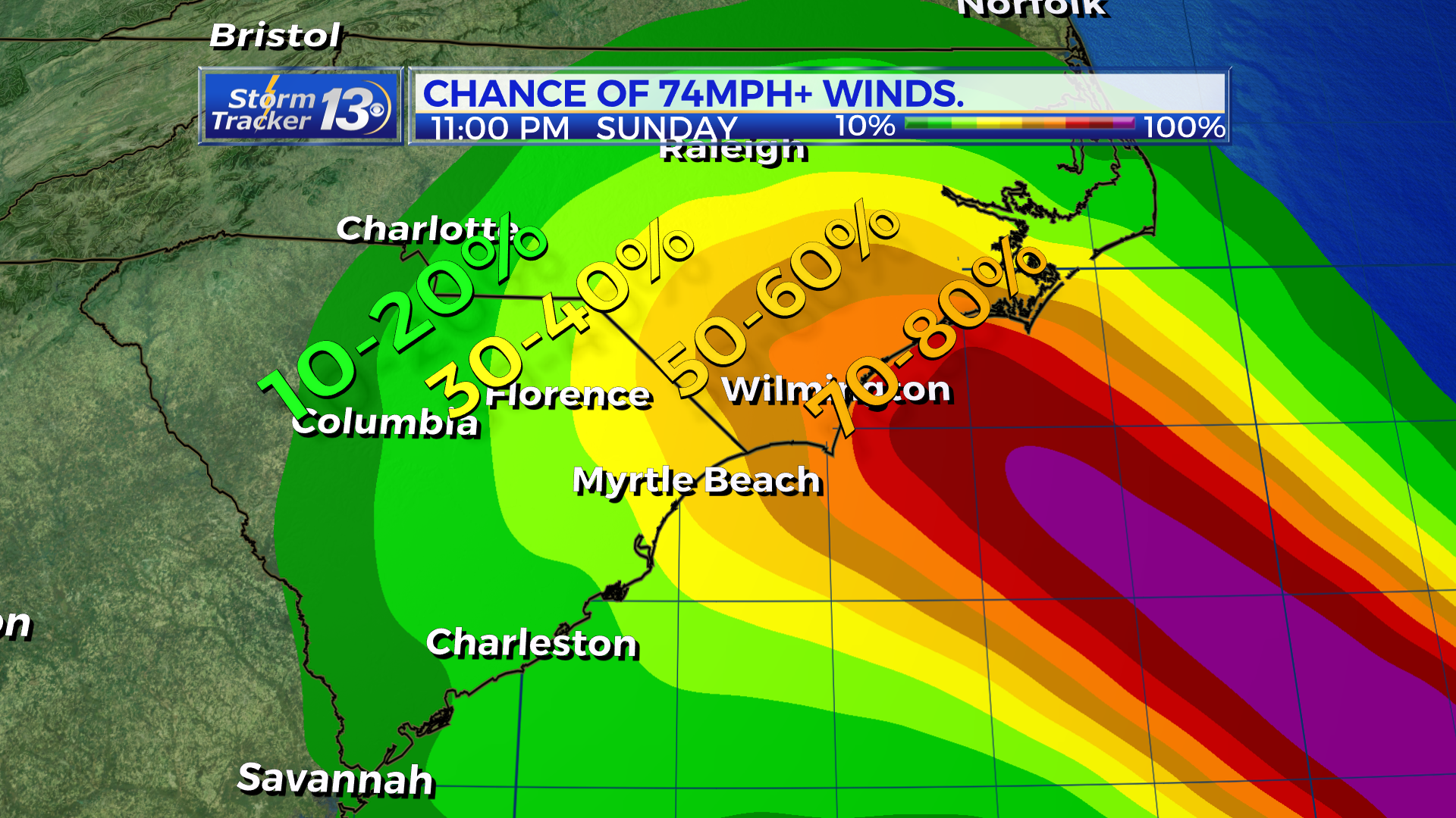
Storm surge forecasts remain largely the same with the potential to see 4-6 ft along the Grand Strand. North of the border, 6-9 ft is possible up through Cape Fear and north of Cape Fear, water could be as high as 9-13 ft at the high tides.
The tornado threat remains low for us as long as we stay south of where the center comes ashore.
Rainfall: This will be an evolving forecast over the next few days as Florence stalls out. The heaviest rain and highest accumulations will occur north of the center. This still puts North Carolina at risk for the highest totals which could amount to upwards of 20+ inches through early next week.

5 PM TUESDAY UPDATE: NEW INFO
STATS: Florence has strengthened as expected this afternoon. Sustained winds are up to 140 mph with higher gusts. Hurricane-force winds extend outward up to 60 miles from the center and tropical-storm-force winds extend outward up to 175 miles. The wind field has expanded due to the eyewall replacement cycle. The physical size of the storm has grown as well to just below 500 miles by 500 miles wide. Movement is WNW at 17 mph. Hurricane Warnings are now in effect for Horry and Georgetown Counties. This means that first instances of hurricane conditions could arrive in 36 hours. A Tropical Storm Watch remains in effect for Scotland Co while a Hurricane Watch remains in effect for Robeson, Columbus and Charleston Counties. Florence is located about 785 miles ESE of Cape Fear, NC.
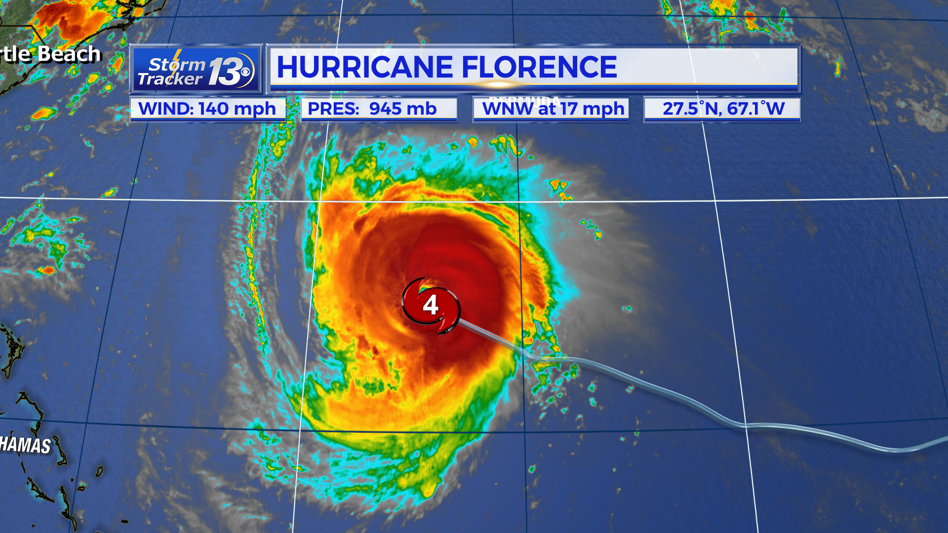
TRACK: A slight westerly shift in the track was made at 5pm due to models waffling to the south a hair this afternoon. This shift does not change our forecast any for the Grand Strand, Pee Dee and Border Belt. The Grand Strand is also still in the cone of uncertainty and the center of the storm could make landfall near us as a few models suggest. The further north the center comes ashore, the better outcome for us in South Carolina.
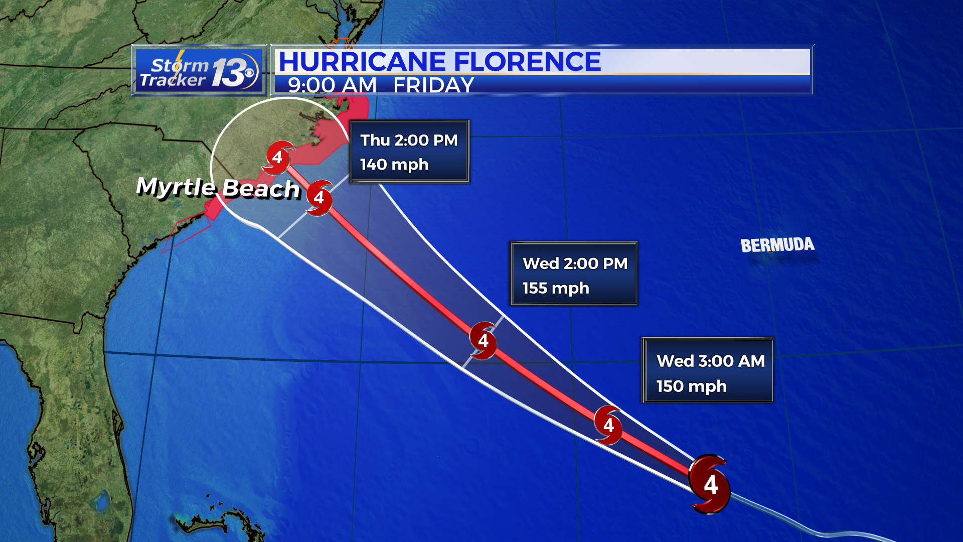
Further strengthening is likely tonight and tomorrow as Florence is forecast to reach it’s peak intensity at 155 mph Wednesday afternoon. This is just below a category 5. After Wednesday afternoon, Florence is expected to slightly before landfall with winds estimated to be at 140 mph as it moves onshore. Current timing suggests that landfall could occur Thursday afternoon or night. However, tropical storm force winds could arrive as early as Wednesday night. Florence is forecast to approach the coast Wednesday evening but slow down considerably as a large trough in the Midwest halts Florence’s forward progression.
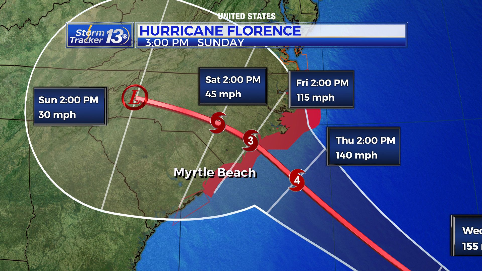
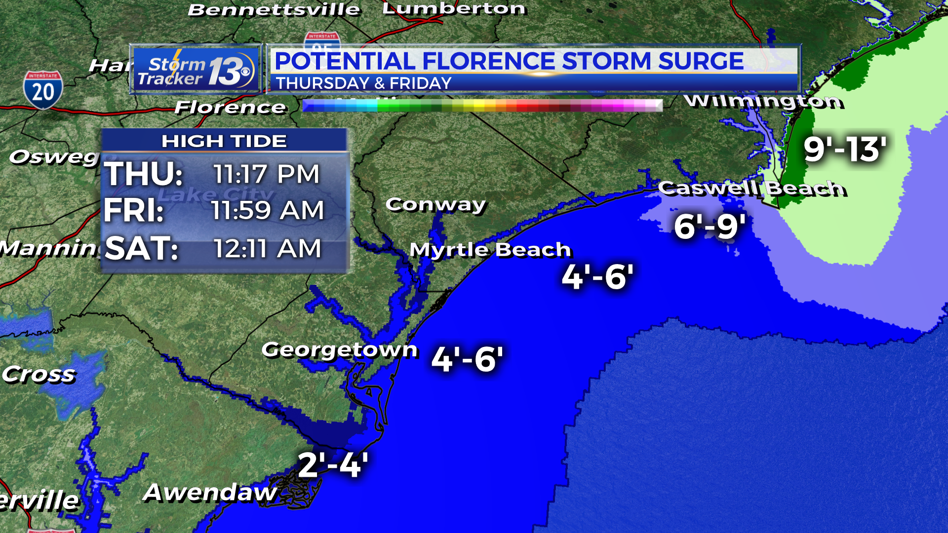
IMPACTS: The storm surge and tornado threat will still largely exist to the right of where Florence’s center comes ashore. However, during high tide Thursday night (11:17 pm,) the Grand Strand has the potential to see a storm surge of 4-6 ft. North of the border, 6-9 ft is possible up through Cape Fear and north of Cape Fear, water could be as high as 9-13 ft at the high tides.
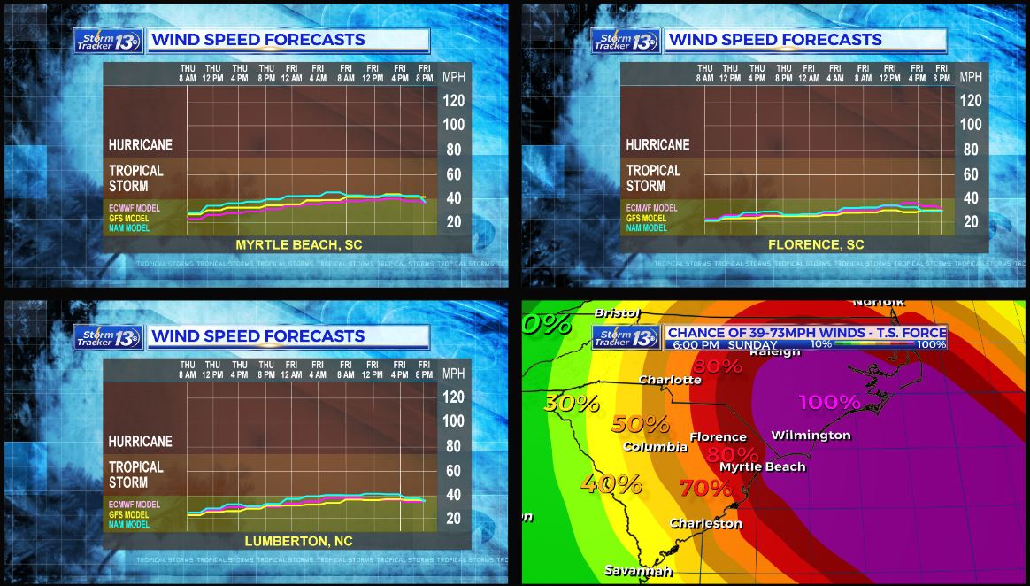
Of course, damaging winds are possible with Florence being such a powerful hurricane. There is still a high chance the Grand Strand will see tropical storm force winds with a medium chance of seeing hurricane force winds.
Flooding is also becoming more of a concern with the potential for Florence to stall out over the Carolinas through the weekend. The storm would weaken in terms of winds but there is a potential for it to dump quite a bit of rainfall through the beginning of next week. No large weather elements will be in the area to move Florence out of the area. We will keep an eye on this potential over the coming days.


