COLUMBIA, SC (WBTW) – With Hurricane Dorian making its way towards Florida, SCDOT is preparing to assist those fleeing the storm.
According to the SCDOT, the department has deployed additional crews to assist evacuees for Florida as they travel north on I-95.
The SCDOT also said “Holiday lane closure restrictions are currently in effect and are scheduled to end at 6 AM on Tues. Sept. 6; however, lane closure restrictions on all interstates and evacuation routes in counties in the eastern half of the state remain in-place until SCDOT gives further notice.”
The department is also preparing for any potential evacuations of coastal counties should they be called for.

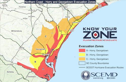
This map from the South Carolina Emergency Management Division shows the three evacuation zones for Horry and Georgetown Counties.
Evacuation areas for Zone A include:
• All areas east of U.S. Business 17 (Kings Highway)
• All areas east of U.S. 17 Bypass
Also includes all flood prone areas along the Waccamaw River and the Great and Little Pee Dee Rivers, as well as all mobile home residents within Horry County.
Evacuation areas for Zone B include:
• Areas South of Highway 707 and Longwood Drive
• Longwood Plantation (Blackmoor) to the Waccamaw River
• Residents/Businesses in Zone A
Also includes all flood prone areas along the Waccamaw River and the Great and Little Pee Dee Rivers, as well as all mobile home residents within Horry County.
Evacuation areas for Zone C include:
• Areas between Highway 701 and Highway 544
• South of Brown’s Chapel Avenue and Highway 814
• All areas east of Highway 31 (Carolina Bays Parkway) to Highway 90
• Residents/Businesses in Zone A and Zone B
Also includes all flood prone areas along Waccamaw River and Great and Little Pee Dee Rivers, as well as all mobile home residents within Horry County.


