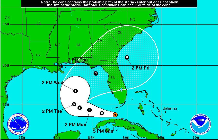
MYRTLE BEACH (WBTW) – Tropical Depression Nine has formed off the Florida coast, about 60 miles south of Key West.
Maximum sustained winds in the tropical depression are 35 mph as of 5 PM Sunday. Movement is west at 9 mph and minimum central pressure is 1009 mb.
This system is forecast to remain a tropical depression for the next 12 hours as it moves west into the Gulf of Mexico and then as conditions improve, strengthen into a tropical storm. If TD Nine strengthens to tropical storm status before TD Eight, it will become Hermine. If it strengthens to tropical storm status after TD Eight, it will become Ian.
Short term impacts: heavy rain 1-4″+ throughout south Florida and the Florida Keys through Wednesday, with locally higher amounts possible. There are currently no Tropical Storm watches or warnings in effect.

Models do not agree well after Tuesday about the direction of Nine’s track and track confidence is not high at this point. Some computer models continue taking it west towards Texas, and other models have Nine make landfall anywhere from the Florida panhandle to central Florida and then moving through Georgia back into the Atlantic. It’s too early to tell which of these tracks Nine will take, but we will have to keep a close watch on it for potential impacts in the Carolinas towards the end of the week.


