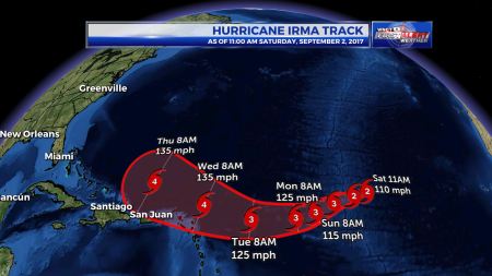
GREENVILLE, N.C. (WNCT/WBTW) – You may or may not have seen forecasts for Hurricane Irma like the one above. They look a lot like a typical track forecast from the National Hurricane Center, but this and others like it are bogus. At this point, no one knows exactly where Hurricane Irma will end up and if the storm will have any impacts on the U.S.
So, how can you spot a fake? Well first, official forecasts from the National Hurricane Center only go 5 days out, much like the one below.

In 5 days, the storm will be closer to the U.S., but nowhere near being a direct threat just yet. In fact, any impacts to the U.S. coast are likely 8-10 or more days away (September 10-12, 2017).
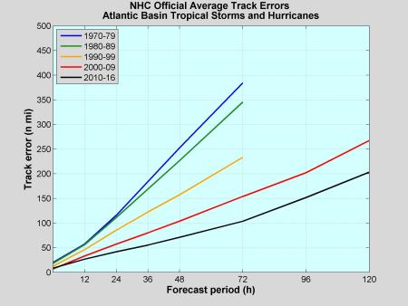
There’s a very good reason why hurricane track forecasts only go 5 days out. Our forecast accuracy for tropical system tracks increases dramatically beyond 5 days.

The accuracy for Days 1-5 has increased greatly since the 1970’s, from a nearly 400 mile average track error at Day 3 in the 1970’s to just 100 miles today. The average track error at Day 5 is 200 miles today and goes up significantly beyond that. This is why it is dangerous to extend a track forecast beyond 5 days. Even if you include the cone of uncertainty, which accounts for the forecast error, it would be so large that it would not be useful for planning for impacts from a tropical system.
In reality, the cone of uncertainty in the fake forecast should be much larger than it actually is.
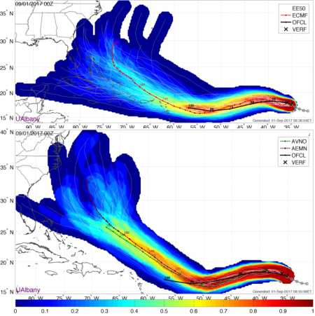
To give you some perspective, here is a map of several different forecast models for Hurricane Irma as of yesterday evening (Friday, September 1. 2017).

Notice the spread in the placement of Irma among the models (in dark blue), from the Yucatán peninsula of Mexico all the way to a harmless curve northeast back out to sea.
Bottom line: It will be several days before we have a better handle on where Irma is headed as it gets closer to the U.S.
Keep up to date on all things weather with WBTW on TV, online, and on the WBTW Stormtracker 13 Weather app.


